by Meryl Marshall (NOSAS)
This is the story of two archaeological sites which have suffered severe damage through a catalogue of assaults by man in the name of “development”. The “patients”, for so they can be regarded, lie in Balblair Wood (read Ward!), near Beauly. They have received repeated injuries over the last 20 years and today are in a sad, sorry state – they have been in the wrong place at the wrong time!
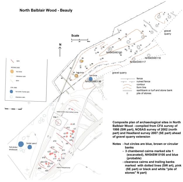
Patient A is (or was) an extensive linear prehistoric site, centred on NGR NH 501444; it once comprised 13 hut circles, 2 chambered cairns, burnt mounds and a field system of clearance cairns and trailing banks occupying an area of 750m x 200m (maybe more) along the SW edge of the wood. Only 12 years ago this beautiful site with clearly identifiable features was well preserved and within open pine woods which had a mossy forest floor. The site was unusual in that it occupied a low lying river terrace quite close to the River Beauly and the Beauly Firth. It was the subject of one of the first NOSAS survey projects; see report on the NOSAS website.
Patient B is the fort known as Corffhouse or Lovat Bridge in the NE part of the wood, NGR NH 5135 4480, Canmore ID 12745, HER No MHG3401; it also has been the subject of a NOSAS survey.
Balblair Wood lies on a gravel terrace on the north side of the River Beauly, 3 kms SW of the village of Beauly. An estate plan of 1757 depicts the area as wooded and has the words “Inclusures(sic) lately planted with firs, birch and etc”. These trees have no doubt been harvested and replanted, possibly several times, over the intervening years. In the 19th Century a road was constructed along the edge of the terrace; of this, more later.
Apart from the trees the prehistoric site remained untouched until the 1990s even though a sand and gravel quarry had been established in the NE part of the wood and a switching station for the electricity power lines had been constructed north of the site in the 1950s. In 1990 the quarry was extended and, in the process, a cist burial (Canmore ID 75185) was excavated and found to contain 2 early beakers, one of normal size and the other smaller; these are now in Inverness Museum. The quarrying continued getting ever closer to our site and by 2003 the site was “high and dry” on an elevated spit of land; this exposure inevitably led to windblown trees during the next winter storms. Further extension of the gravel quarry in 2005 threatened the west end of the site and the archaeological work prior to this identified a total of 18 sub-circular clearance cairns and 10 other linear stone banks as a result of monitoring during the topsoil stripping operations. It is worth commenting that the quarrying up to this point had probably destroyed similar field systems which went unnoticed and unrecorded.
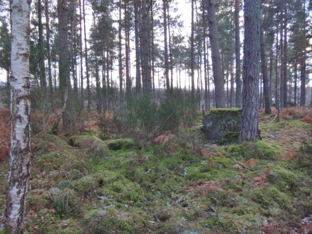
The chambered cairn HER No MHG27977 (NH54SW0100), at NGR NH 5024 4457, looking south. This photograph shows a small part of the site/wood as it is today
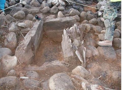
The chambered cairn, HER No MHG29161 (Site 1 on the above map) was earmarked for removal; it was excavated and found to contain a cist (above) with an unusually decorated side slab, (below) photographs by Headland Archaeology Ltd.
Quarrying at this end of the wood continues today and encroaches to within 20m or so of what remains of the prehistoric site.
Meanwhile, at the east end of the site, upgrading of the Balblair Switching Station for the Beauly to Denny Power line in 2013 has resulted in an even more disastrous outcome – the disappearance of 7 hut circles, 9 clearance cairns and several trailing banks, almost half of the original site. Now, 12 years after our NOSAS survey, the site lies forlornly in a desolate state having been reduced to 6 hut circles, 1 chambered cairn and several clearance cairns. Much of it is obscured by windblown trees and the surrounding context has been entirely lost.

The features at the east end of the site have disappeared. Hut circle NH64SW0118 is in the foreground
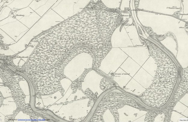
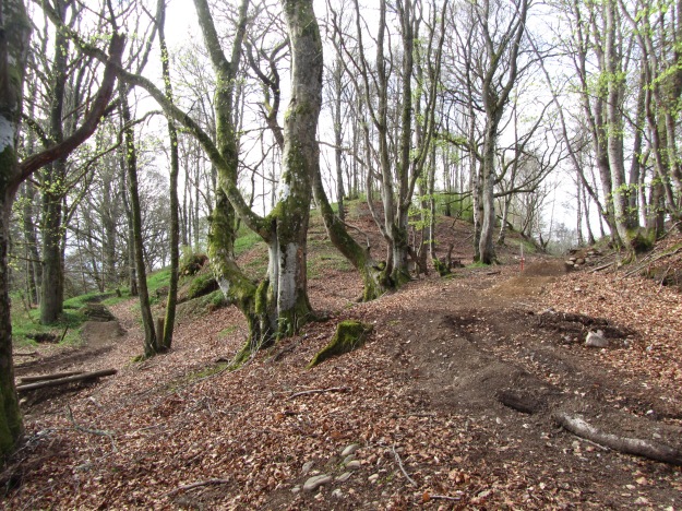
Patient B, Corffhouse fort, is in a strategic position next to the river crossing; it is planted with trees, just as the prehistoric site, but with beech trees. The road, constructed in the 19th century and previously mentioned, cuts through the fort cleaving it in two as it mounts the river terrace from the river crossing; it is well seen on the First Edition OS map. In addition what is probably an earlier track appears as a terrace climbing the eastern flanks of the fort.
The sand and gravel quarrying of the 1950s resulted in truncation of the western part of the fort. Thereafter dumping of rubbish over the next few decades obliterated the remaining area of this arc amounting to one third of the fort. More recently bikers have been performing their “stunts” over the humps and hollows of the ramparts and a series of “gouged out” twists, turns, peaks and troughs have developed; the steep inclines and changes of slope make ideal terrain for the sport but are not very good for the archaeology!
Clearly Balblair Wood has been a significant location in the past; the survival of these two archaeological sites for hundreds, even thousands of years, is a miracle considering their low-lying position within an agricultural area. That so much devastation has happened in the recent past is reprehensible; this is a part of our culture which will not be available to future generations. One can argue that gravel is needed and it is essential that our power lines are upgraded but surely this is a high price to pay.
So what is to be done? At least there is something left of the two sites and these remains could go part way to indicating the presence and state of the former site. The fort is scheduled by Historic Scotland and the legal process should ensure some protection, but the prehistoric site was not scheduled. The prognosis for what is left of this site is poor; it will surely “die a death” if it continues in its present state. But an alternative could be to administer some tender loving care by clearing it of debris, fencing it and developing it as a site to visit, thus giving it some dignity and quality of life; it would be a formidable task and who should do it………….?
Bibliography
Dutton, A Feb 2005 Results of Archaeological Excavation, Balblair Quarry, Beauly
Dutton, A, Clapperton, K, Carter, S Rock Art from a Bronze Age burial near Balblair, Inverness, – Proc Soc Antiq Scot 137 (2007), 117-136
Hanley, R & Sheridan, A 1994 ‘A Beaker cist from Balblair, near Beauly, Inverness
Marshall, M 2002 Report of NoSAS Field Survey of Part of Balblair Wood, Beauly.
May, P 1757 A plan of that part of the Annexed Estate of Lovat lying in the parish of
Kilmorack and county of Inverness. RHP 6568.
Neighbour, T 2000 Balblair Wood, Archaeological Survey. Client report of CFA Ltd.
Thomson, J 1830 Northern part of Inverness Shire.
Ordnance Survey 1872 Inverness-shire X.3 & X.7 1:2500. Surveyed 1872.


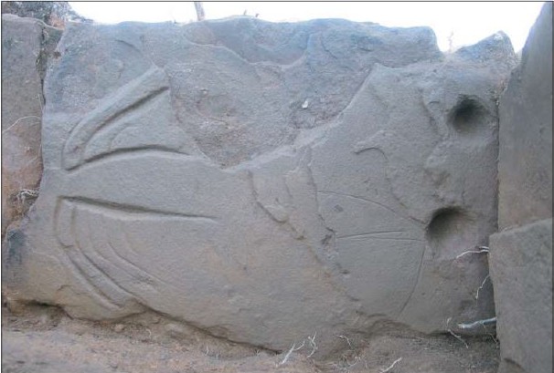

Such a beautiful place, and in a strategic location. We can also add the Pictish presence (STAMS > Balblair), both stones seem to have been located in this location. One stone holds the same birdman-with-club figure found at Cunningsburgh, Shetland, where the Pictish place later became a kingly residence under the Norse with a significant church. The triple-oval symbol on the symbol stone is also found on the three main old churches of Caithness, another indication that Beauly too may have been a major sacred centre early on. Not yet direct evidence that Beauly was a major Pictish centre, but certainly suggestive. And definitely worth conserving.
LikeLike
Thanks Helen. For those who are interested the two Pictish stones appear to originate at Wester Balblair (just across the A831, immediately to the north of the fort and Balblair Woods site). The “birdman” stone, which is also cup marked, has been moved a couple of times in the last 200 years and is now in the grounds of Moniack Castle – http://canmore.rcahms.gov.uk/en/site/269922/details/balblair/. The triple oval Class I symbol stone was found in a garden in the 1960’s and is now in Inverness Museum – http://canmore.rcahms.gov.uk/en/site/12674/details/wester+balblair/.
LikeLike
The blog post has created some discussion about the scheduling of the prehistoric site at Balblair Woods; not to my knowledge was this site ever considered for scheduling although HS must have known about it as it was brought to my attention by the Historic Scotland Warden in post at the time. I do wonder if scheduling would have made any difference in this case though; there was possibly no alternative options other than this one for upgrading the Electricity Switching Station on the Beauly to Denny line.
There was a similar case thirty or so years ago when the line of the A9 bypass in Inverness took precedence over a scheduled monument, the Raigmore Chambered Cairn, it was demolished but reconstructed nearby! It is also worth making the point that the planning regulations require that the developer has to fund proper recording and investigation of the archaeology; the excavation of the cist and the chambered cairn wouldn’t have taken place had it not been for the gravel quarry and we wouldnt have known about the beakers or the incised stone; also the cultivation remains in the south part were only revealed with the removal of the topsoil – I remember walking over that area 10 years ago, it was hard going in rampant heather and no features were apparent! This makes the point that there is so much archaeology that is unacknowledged and unrecorded.
LikeLike
A lovely, if not poignant and sad article, Meryll.
I agree that it is truly a double-edged sword; without development, no (or fewer) archaeological discoveries. We are enriched in one sense, but at a loss in another.
Perhaps we should just be thankful that we live in an area where precious little is under threat, compared to, say the Central Belt, or even Inverness itself. There is still so much left for us to see, wonder at and, if the notion takes us, be active and record. Which, perhaps, leads on to another pertinent, follow-up question – should we (as groups, such as NoSAS, or even individuals) become more pro-active in encouraging the scheduling with HS of more sites? I would like to think that a SAM now has a greater perceived degree of protection that the Raigmore Chambered Cairn, however, I may be mistaken!
LikeLike