by James McComas (NOSAS)
The Pictish people of the mid to late first millenium AD once inhabited what is now northern and eastern Scotland. They left very little written record and the evidence of buildings so far identified are sparse. Perhaps their most obvious remains in the landscape are the enigmatic symbol stones and the imprints of their burial sites.
Although modern Angus and Perthshire have traditionally been seen as the Pictish heartland, in recent years new research is reveavaluating the importance of the northern picts, north of the Mounth. Two highland burial sites which feature impressive upstanding remains are to be found on opposite sides of Loch Ness; at Garbeg near Drumnadrochit, and at Whitebridge in Stratherrick. Pictish funerary practices appear to have been diverse (see our earlier blog post), however barrow* cemeteries have been identified as one recognisable form. Round and square type ditched barrows appear alongside each other at both Garbeg and Whitebridge – a feature thought to be unique to the Pictish cemetery.
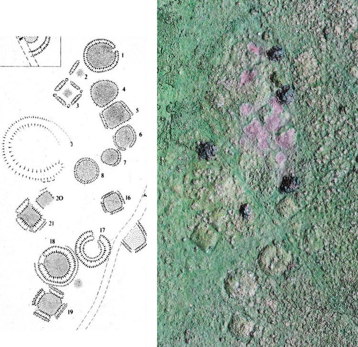
Side by side comparison of a plan of part of the Garbeg cemetery and a quadcopter aerial photo by Alan Thompson. (The brown patches on the photo are the result of recent gorse clearance, and dark green areas are piles of cut vegetation.) The barrows excavated by Wedderburn and Grime on this plan are nos 1,2,3 and 8.
Garbeg and Whitebridge were visited by NOSAS field trips in 2014/ 2015 and Garbeg has also been the subject of gorse clearance, quadcopter photography (blog post section 4) and QGIS survey by the group. Subsequently in 2015 many NOSAS members were involved with survey and excavation by the University of Aberdeen’s Northern Picts Project on possibly contemporaneous building remains at Garbeg.
The cemetery at Garbeg (Canmore ID 12281, HER MHG3361) consists of 23 square and round barrows with surrounding ditches. The barrows are thought to cover single long cist burials. They are situated on a natural plateau at an altitude of some 300m on open moorland used for rough grazing. The immediately surrounding landscape is one rich in archaeological remains, including prehistoric field systems, groups of hut circles and a series of burnt mounds which are largely thought to predate the Pictish period.

Members of NOSAS at a field visit to Garbeg, November 2014
The Pictish site was initially recognised in 1974 after the landowner JLM Younie found a fragment of a class 1 symbol stone (c. 7th C AD) whilst digging in one of the barrows and reported this to archaeologists. The site was excavated by soon after by Laurie M Wedderburn and Dorothy Grime. Their aim was to glean as much information as possible from the already disturbed structure and to try to prove whether the structure and symbol stone were contemporary.

Fragment of Pictish symbol stone found at Garbeg, showing how the design may have continued. The stone is now in the Inverness Museum.
A total of four trenches were dug across barrows at Garbeg. Of particular interest was one of the square barrows where baulks had been left at each corner of the surrounding ditch and here a small boulder had been placed. At the centre of this barrow was a rectangular stone setting measuring 2.4 x 1.7 m with an E-W orientated long grave beneath. From this grave were recovered a human skull and femur. Similar structures were found in the two other trenches, whilst in an outlier, the central pit had been lined with boulders to form a massive cist.

Excavation shot of square barrow at Garbeg with small boulders set at each corner. Note the central stone cairn on top of the earthen platform (courtesy of Laurie and Dorothy Wedderburn)

Close-up of barrow ditch with baulk and boulder at the corner (courtesy of Laurie and Dorothy Wedderburn).
Only one other barrow yielded definite finds in the form charcoal, calcined bone and an undecorated pottery fragment; categorised as Scottish ware dating from the 1st millenium BC onwards. Unfortunately no clear statigraphic relationship could be established between the stone and the barrow, however this may have been due to the disturbance prior to excavation.

Square ditched barrow at Garbeg (HER)

Round ditched barrow at Garbeg (HER)
Radiocarbon dating results from Garbeg have proved to be problematic. The skull and femur fragments were recovered from barrow no. 3 (see plan above, the symbol stone was in no.1). These skeletal remains were tested 10 years after excavation in 1985, achieving a date of 990 bp +/-50, calibrated to AD 900 to 1190 (http://canmore.org.uk/c14index/12633). Even at the oldest end of the range this would place our individual in what is usually thought to be the post Pictish era.
Subsequently the bones were retested in 2013 as part of the University of Aberdeen’s Northern Picts Project. This time they attained a result of 933 bp +/- 33, calibrated to AD 1035-1155. If correct then the burial date might be 4 or 5 centuries later than the carving of the symbol stone and well into the period where we might have expected church burials to be the norm. However, I corresponded with Kate Britton of the University of Aberdeen who pointed out that d13C values were suspiciously low, and on the carbon and nitrogen mass spectrometry data the C/N ratio was very high. This meant that although the date could be genuine, it is also quite possible that the collagen sample is either contaminated or poorly preserved leading to unreliable results. Kate doubted that the original 1985 RC dating incorporated the assessment of collagen preservation at all, so these reservations may have slipped the net previously.

Human remains in situ at Garbeg (courtesy of Laurie and Dorothy Wedderburn).

Graph shows an amalglamation of all c14 date results available for cairn and barrow graves in Pictish cemeteries tested as of 2014 (Adrian Maldonado). The commonest date is between 400 and 600 AD which is much closer to the result we might have expected for Garbeg.
Although some of the barrows can be difficult to pick out today, in the period of their use they would have stood taller and their ditches would have been more defined. There may also been associated markers or upright stones on graves which are no longer visible, or indeed at the corners of the square barrows as discussed above.
Garbeg is one of a group of burial sites that have been found in association with class 1 symbol stones. The others include Dunrobin, Tillytarmont, Waternan and Ackergill. At Dunrobin in Easter Ross, the symbol stone originally stood upon a rectangular cairn beneath which skeletal remains in a cist were radiocarbon dated to the 6th to 8th centuries AD.

An artist’s impression of a Pictish burial (Mike Moore). A body is being placed into a long cist grave, whilst the monument in the background has standing stones at each corner and a symbol stone set on top of the cairn.

An Artist’s Impression of square and round ditched barrows, as they might once have appeared at Garbeg and Whitebridge (Alan Braby)
The cemetery site at Whitebridge, in Stratherrick (Canmore ID 12281, HER MHG2637), comprises four square barrows, two ditched round barrows as well several unditched cairns. They lie on two adjacent gravel terraces separated by an old river channel. Although there are fewer structures than at Garbeg, it is possible that historic river erosion and later agriculture/ settlement have curtailed a site that was once more extensive.
As late as the sixties, Whitebridge was still being incorrectly described as a camp associated with the military road of c 1725. The post medieval reuse of the site with corn drying kiln and various buildings, plus tattie pits on the the river terrace to east seems to have confused identification further. Only in 1979 did the OS survey note that “these structures were re-examined in the light of new evidence.” This evidence was largely provided by the advent of aerial photography identification of barrow sites in the seventies. In most cases these have been recognised only through crop marks, since upstanding barrows have proved especially vulnerable to the depredations of the plough.

Round barrow with pennanular ditch and surrounding bank at Whitebridge

Square ditched barrow with bank and causeways, Whitebridge
Many similarities have been found between Garbeg and Whitebridge, so much so that barrow cemetries can be described as being of the Garbeg/ Whitebridge type. These are “characterised by containing low flat mounds surrounded each by a small ditch, by the presence of rectangular or trapezoidal mounds in addition to circular ones, and by the presence of gaps at the corners of the ditches of the straight-sided mounds” (Ashmore, 1980).
The main differences between the two are that the Whitebridge barrows are slightly bigger in area and that they have outer banks, which are largely absent from their Garbeg counterparts. Also, whilst the corners of the square barrows have gaps both at sites, at Whitebridge no corner stones have been detected (see OS 1979 conclusions on Canmore ID 12281). All the individual barrow features seen at Garbeg and Whitebridge can also be seen found at much older sites; it is the combination of barrow types occurring together – round and square, ditched and causewayed – that identify them as Pictish.

The only excavation to date at Whitebridge has been a very limited one in 1999, carried out due to a fallen tree which had clipped the edge of one unditched cairn. Here it was noted that no trace of a surrounding ditch or bank was recovered and there were no indications of a burial ground surface below the cairn (see the Data Structure Report). Unlike Garbeg therefore, no skeletal remains or other artefacts have been recovered which might provide dating confirmation.
One further upstanding barrow site which NOSAS visited on the same day as Whitebridge can be found at Brin Nursery, Stratherrick – Canmore ID 78792. This is another possible cemetery originally classified as a result of aerial photography. Here there are four round barrows and what may be two conjoined square barrows with causeways. Although the features are by no means as defined as at Garbeg or Whitebridge, the similarties are striking enough to make for an interesting comparison. Another highland barrow site with markedly shared characteristics can be seen at Pityoulish near Aviemore (Canmore ID 15389).

Drawing of Brin Barrow Cemetery (RCAHMS).
And so what can be done to improve our understanding of these sites in the future? The Scottish Archaeological Research Framework (ScARF) argues that study has been “gravely inhibited by the lack of any developed cemetery archaeology.” Indeed there has been no new detailed survey or significant excavation at Garbeg and Whitebridge for many years, if at all. Since the 1970s technologies have advanced considerably, and it may be possible now to resolve questions that were unanswerable when these sites were originally classified. ScARF goes on to state that
…there are sites of great potential that are protected, but not properly studied: e.g. Whitebridge and Garbeg. Large scale excavation may not be appropriate at such precious resources, but research could be advanced by using non-destructively using precision survey, caedmium vapour magnetometry and soil sounding radar, and then testing selected anomalies by excavation with microstratigraphic and chemical plotting – all well developed techniques. (http://www.scottishheritagehub.com/content/45-burials)
*A note on barrows and cairns
A barrow is usually defined as a mound of earth, or of earth and stones, used to cover one or more burials. By contrast, a burial cairn is strictly speaking constructed entirely of stone. Some past commentators however do describe the mounds at Garbeg and Whitebridge as cairns. This can be somewhat confusing, especially since both sites do also feature cairns in the vicinity which are probably not burials. There is indeed an extensive cairnfield at Garbeg which is more likely associated with prehistoric farming.
Stone Pictish burial cairns, both square and round, however do occur on several other sites such as Ackergill and Dunrobin. The diagram below shows the distribution of Pictish cairn and barrow cemetery sites in central and northern Scotland. There is a mixed picture in the south east of the region, but in the central highlands, Moray and Aberdeenshire barrows seem to predominate. In the far north and west however only cairn burials have been identified.

Distribution of Pictish cairn and barrow cemetery sites (Adrian Maldonado).
Bibliography
Ashmore, P.J. Low Cairns, Long Cists and Symbol Stones (1980)
Bridgland, N. Urquhart Castle and the Great Glen (2006)
Carver, M. Surving in Symbols (1999)
Close-Brooks, J. Pictish and other Burials (1984)
Foster, S.M. Picts, Gaels and Scots (2014)
Maldonado, A. Burial in Early Medieval Scotland:New Questions (2013) and Groam House Academic Lecture (2014)
Stevenson, J,B. Garbeg and Whitebridge : Two Square-Barrow Cemeteries in Inverness-shire (1984)
Wedderburn L.M and Grime D. The Cairn Cemetery at Garbeg, Drumnadrochit (1984)
Williams, H. Depicting the Dead: Commemoration through Cists, Cairns and Symbols (2007)
Many thanks to Laurie and Dorothy Wedderburn, Kate Britton, Fiona Younie, Oskar Sveinbjarnarson, Juliette Mitchell and numerous members of NOSAS – especially Jonie Guest.

The 1970s excavation at Garbeg (courtesy of Laurie and Dorothy Wedderburn)

Very interesting and well researched.
LikeLike
Pingback: The Historical Context of “The Speaker of Anglorum” – Anglorum
Nice reminder that the Picts existed
LikeLike