Tag Archives: Scottish archaeology

Cairns in Clusters: Chambered Cairns in Assynt

By Gordon Sleight

Carrachan Dubh chambered cairn near Inchdnadamph

Over the last twenty years I have thoroughly enjoyed tramping around Assynt, sometimes on my own and sometimes with groups of friends.  That sense of enjoyment is often enhanced by surprises.  It might be disturbing a mountain hare and seeing it race away at speed or watching an overhead confrontation between golden and white-tailed eagles, but those events have been rare. More frequently the surprises have been coming across all sorts of unrecorded archaeological sites. A classic example happened about 10 years ago when a small group of NOSAS and Historic Assynt members set out to look for rock art in Assynt and after several days of searching, completely failed to find so much as a single cup mark!  But the effort was rewarded with several surprises – an iron working site, a roundhouse, a chambered cairn and at least one smaller cairn with signs of a cist in the centre, none of which had been recorded.

Assynt has a relatively dense cluster of cairns concentrated in and around the valley that links Ledmore Junction and Inchnadamph.  Many of them were recorded long ago and described in detail in Henshall (1963, 1972) and Henshall and Ritchie (1995). However, in recent years finding ‘new’ cairns in the same area has become almost normal, but no less exciting! Overall numbers have now almost doubled to at least 30 chambered cairns and 14 smaller round cairns.  The Assynt cluster is now one of the largest concentrations known anywhere in Scotland and the numbers continue to increase.  The best preserved are now all scheduled and the scheduling highlights the fact that these are all part of a significant cluster. This high survival rate, which applies to other archaeological sites in Assynt, is most probably because the area has always been sparsely populated with little intensive farming or other forms of large-scale development.

Bad na Cleithe chambered cairn
Recently discovered chambered cairn, 500m from Bad na Cleithe Cairn
Continue reading

Highland Heritage Day 2023: A Way Forward?

by Susan Kruse

Did you know that there are around 100 heritage organisations and over 50 museums in the Highlands – and a number of community trusts and individuals who have heritage projects on the go? Few of us know what others are doing, and we rarely have a chance to meet up. ARCH has over the years tried to find out contact details, in part due to work organising the Highland Archaeology Festival over the last 7 years on behalf of Highland Council Historic Environment Team.

It seemed time to organise a day when we could meet up, promote our activities, and share problems and successes. The last time was over 15 years ago in Strathpeffer, and I remember what a great event that was! ARCH applied for funding from Historic Environment Scotland to cover venue hire, catering and transport costs for people, with further organising support donated by ARCH. Representatives from NoSAS, Museums Heritage Highland, Wardlaw Trust and Highland Archaeology Services helped to plan a heritage day, leaving lots of time for networking and discussion. A number of volunteers also helped with lunches and logistics on the day.

Around 130 people from 60 organisations from throughout the Highlands came to Dingwall Academy on the 4th March 2023.  Most groups brought a stall to showcase their work. In the morning there were discussion groups to discuss common problems facing heritage organisations, including thoughts on how to address these, and ways to collaborate with one another. In the afternoon five parallel workshops were run addressing issues of volunteering, engaging with the community, climate change, organisation sustainability, and funding.

Continue reading

Rhynie Excavations Season 4 (2016)

By Cathy MacIver (on behalf of the REAP Project Team)

A fourth season of excavation took place at the Craw Stane, Rhynie over August – September 2016. The project was led by REAP Project Directors Dr Gordon Noble, University of Aberdeen and Dr Meggen Gondek, University of Chester.

Aerial photographs and geophysical surveys had identified curvilinear enclosures around the Craw Stane, one of the few symbol stones remaining in situ in Scotland (Plate 1).

image001

Plate 1: Craw Stane with Tap O ‘Noth hillfort (©Cathy MacIver)

Previous seasons of work at the Craw Stane (one of seven Class I Pictish symbol stones from the area) in 2011, 2012 and 2015 had demonstrated that these enclosures took the form of an inner and outer ditch and a later palisade structure with associated postholes.

Excavations in past seasons had revealed a number of high status objects including fragments of Late Roman Amphora, glass beads, metal pins, glass vessel fragments and evidence of metal working in the form of metal working tongs, slag (metal working waste) and clay moulds for metal objects. The features date the site to the early medieval period and radiocarbon dates from the ditches and other internal features confirmed a relatively short 5th-6th C construction, occupation and abandonment of the site.

image003

Plate 2: Rough draft of the excavations from 2011, 2012 and 2015. A work in progress!

The 2016 excavations aimed to investigate areas of the site that hadn’t been looked at before, continuing to use the successful strip and map approach employed in previous years. This involved 4 large areas or trenches (Plate 3) where the topsoil was removed by machine and watched by archaeologists. The areas were then cleaned by hand by a team of archaeologists, students and volunteers, using hoes, krafses and eventually trowels. This made archaeological features more visible and easier to record. Plans of the site were created using DGPS (accurate to the nearest cm) and aerial photography using a drone. Areas with more complexity were drawn by hand.

image005

Plate 3: Aerial view of the 2016 trenches

Continue reading

Mulchaich 18th Century Distillery, Ross-shire: a NOSAS Project

by Meryl Marshall (NOSAS)

Mulchaich Kiln excav 16th Aug13 008

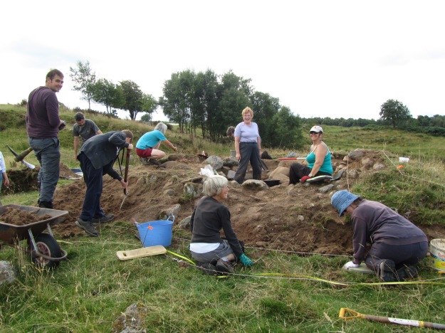
NOSAS members working at Mulchaich 16th August 2013

Over the years tradition has had it that there are the remains of a distillery dating back to the 18th Century at Mulchaich Farm, located in the district of Ferintosh on the Black Isle. The distillery site is about 200m NW of the farm and was previously unrecorded; it was in a sorry state being quite overgrown with whins and with the few open areas grossly trampled by cattle. In 2009 members of the North of Scotland Archaeological Society began a project which had as one of its aims the surveying and recording of the distillery site and that of the neighbouring chambered cairn (HER MHG 9083). The project also included a limited amount of historical documentary research following which a report was produced – see also Appendix II below for further details.

It was felt that together with the chambered cairn the distillery site would make an interesting and attractive place for people to visit. The landowners, the Dalgetty family, were happy to oblige with permission and for this we are very grateful. In addition the Adopt-a-Monument Scheme hosted by Archaeology Scotland were keen to help us with advice and limited funding, so in October 2012 NOSAS began a second phase of work at Mulchiach, preparing the site for public presentation. It is this later project that forms the chief focus of the following article.

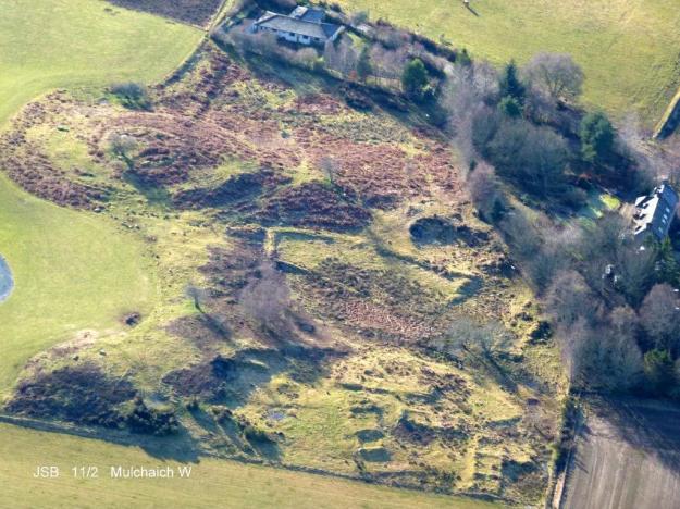
Mulchaich Farm, west settlement and chambered cairn – Aerial photo taken from the north

Mulchaich Farm, distillery site (west settlement) and chambered cairn – Aerial photo taken from the north

The Mulchaich Kiln

The main thrust of the work during the summer of 2013 was targeted at the kiln where the barley or bere, which had been allowed to germinate, would have been made into malt by gently heating it until it was dry . The kiln had all the characteristics of a corn drying kiln and the purpose of our exercise was to clear the rubbish that was inside it so that its features could be displayed and we could interpret them for visitors. The work was carried out as if it was an excavation; nothing structural was removed, everything was recorded as we went along, photographs were taken at all stages and a report was subsequently published.

The kiln bowl had been constructed on a small mound of glacial till which had been levelled off to form a platform. The platform was built up on the east side and reinforced with boulders and the kiln bowl itself was sunk into the natural morainic till by 200mm; likewise the flue and the area in front of the entrance which was sunk by 500mm.

Continue reading

The Rosemarkie Caves Project

by Simon Gunn (NOSAS)

The subterranean section of NOSAS, the Rosemarkie Caves Project (RCP), is planning more work in the caves this year (2015). The RCP was set up to research the archaeology of the caves on the Moray Firth coast near Rosemarkie.

The group started its work in 2006 with a weekend excavation of Learnie 2B when evidence was found of occupation and leatherwork in the 19th century, probably by summer travellers. This was followed by a more ambitious 14 day dig at Cairds’ Cave in 2010, when we confirmed that the cave had been excavated 100 years before by local doctor William MacLean. Through analysis of bone and charcoal, the cave was found to have been in use as far back as 300BC, the time of Alexander the Great.

2006 dig at Learnie 2B

2006 dig at Learnie 2B

Outside Cairds' Cave in 2010

Outside Cairds’ Cave in 2010

There are 19 caves on this 2.5 mile stretch of coastline, they have been high and dry for over 4000 years and apart from interest by RCP and Dr MacLean, their archaeological potential has never been explored. Since 2010, the RCP members have surveyed all 19 caves and then in 2013 started a program of test-pitting. The purpose of this was to get a feel for the archaeology that might be there, but mainly to find deep samples of bone and charcoal for dating which would ascertain in which periods the caves were used and to find out, if possible, the earliest occupation.
Continue reading

Experiments using a Quadcopter for Archaeological Aerial Photography

by Alan Thompson (NOSAS)

Introduction

I’ve had my Quadcopter for over a year now, had great fun flying it, and have produced many interesting images.  I recently showed a selection of images at a NOSAS evening, and was asked if I would write this blog and share some of the things I’ve learned along the way.

Of course the pictures are what it’s all about and even if you’re not interested in my comments, I hope you enjoy looking at them.

Background

Inspired by some of the wonderful aerial photos (APs) I’ve seen (for example on Canmore) I have long thought how good it would be to be able to take such pictures of our own archaeological sites.

For several years I have been interested in photogrammetry and experimented with that, especially of rock art where the production of a 3D surface and use of computer generated lighting and shadows can give some great effects.

In 2013 I began to investigate kite aerial photography (KAP) but the possibility of using a Quadcopter also emerged and I realised that technology and prices were moving so quickly that it might be a better option.  In early 2014 I decided that the only way to learn was to buy one.

The Quadcopter – getting ready to fly

Most amateur Quadcopters are sold with very wide angle cameras, with the intention of video recording, and also providing a pilot’s view (called first person view or FPV).  This is less than satisfactory for archaeological aerial photography, and so I bought a Quadcopter without a camera, with a view to fitting my own.

The camera is obviously critical, and it needed to be light (ideally <300g including battery), robust, of good enough quality, and with an interval timer.  Unfortunately I could find no such camera.  All those with interval timers are heavier, for example those used for kite aerial photography.  A solution can however be found in that a group of people spend their time hacking the software of Canon cameras (google CHDK) and provide a hacked version for some models which enables an interval timer to be run.

Having bought and hacked my camera and got the interval timer working I had to fit it to the Quadcopter.  The main problem is the high frequency vibration from the rotors which renders the pictures useless.  A suitable anti-vibration mounting was needed, all within the weight limit.

Next, to prepare for the first test flight.  The web (YouTube) is full of videos of alarming crashes and fly-aways.  The Quadcopter instructions are daunting saying that a first flight should be from the middle of a large field, with no wind and no people about.  There is also the matter of insurance (it could certainly hurt someone badly), and the possible need for a CAA licence.  The regulations here are changing quickly but at present as a hobby flier I can insure through the British Model Flying Association (BMFA), and (unlike a professional archaeologist) have no need of a CAA licence provided I fly within line of sight, avoid certain areas (eg near airports) and limit the height.  I would again emphasise that this is all very much in the news and changing and my observations here will quickly be out of date.

Quadcopter flying

The first flight is bit nerve-racking, but set to auto mode the Quadcopter uses its own GPS and compass and is set so that (more or less) if you let go of the controls it just hovers where it is.  Flying in this mode is reasonably straightforward.  I have not dared try any of the advanced modes as yet.

Continue reading

Bronze Age Beaker and Cist Burial in Drumnadrochit

by James McComas (NOSAS)

Go to foot of post for discoveries at the Compass Housing Development 2017 -2018.

Drumnadrochit, by Loch Ness. On the flat former croft land between the Rivers Coilte and Enrick a new NHS Medical Centre is under construction. In January 2015 workers on the site removed a large stone slab. Beneath the slab, undisturbed for perhaps 4000 years, were the crouched remains of an individual resting in a stone lined cist, approximately 0.7 metres deep.

DSC_0016 - Copy

Burial Cist in Drumnadrochit (Courtesy of Mary Peteranna/ AOC)

Initially Highland Council archaeologists assessed the site, concluding it was probably bronze age.  A skull and possible femur were clearly visible, but there were no obvious sign of grave goods. However it was still clearly an significant discovery. Nothing similar had been found in Drumnadrochit before, and whilst there is a profusion of archaeological sites in the area, nothing of this antiquity is known to have been found in the flat lands around Urquhart Bay. The next step was for NHS Highland to appoint an archaeologist to excavate the burial.

I called in briefly to the site several days later to find that the archaeologists appointed were well known to NOSAS – Mary Peteranna, now of AOC, and Steve Birch. Steve was kind enough to give me a brief rundown on what they had found.  It was apparently a fairly typical stone lined cist burial of the early bronze age. The large cap stone, which had been removed by digger when clearing the area, had possibly already been broken in antiquity. There was a thickness of several cm of gravel above the cap stone before digging work began.

The cist during excavation (Courtesy of Mary Peteranna/ AOC)

The cist during excavation (Courtesy of Mary Peteranna/ AOC)

Continue reading

Clava Type Cairns of the Inverness Area

by Anne Coombs (NOSAS)

Clava cairns are unique to a small area of Eastern Highlands of Scotland.  Identified originally along the valley of the River Nairn, a good start point for any tour of these sites is at Balnuaran of Clava near Culloden. Here Historic Scotland cares for a well preserved group of three circular burial cairns in a small area with a car park and interpretation panels (see the H.S. leaflet). Surrounded by trees beside the river this location can provide an atmospheric even ‘sacred’ sense of the past, especially at mid-winter or in the spring.  Two small chambered passage ‘Clava’ cairns with their associated stone circles are sited on either side of a ring cairn with its own stone circle.  The ring cairn (Highland Council HER MHG4366) appears to have been built at a similar time as the other cairns but is likely to have been used for a different purpose as it seems to have no entrance and may never have been roofed unlike the other cairns.  On the west of the site there is a later small kerb cairn part of later reuse of the cemetery 1000 years later.

IMG_20150102_113716

The NE Cairn at Balnuaran of Clava, as seen on a NOSAS field trip in January 2015 (Alan Thompson)

Clava20East20Cairn20nr20Inverness-Archaeology-

The NE Cairn from the air (Scotavia Images)

The two chambered passage cairns (See HER MHG3013 and MHG3002) fit the ‘standard’ ‘Clava’ type with large stones on the inner and outer faces forming a kerb with a substantial fill of smaller stones between.  The passages are aligned to face the mid-winter sun at the solstice and experiments have shown that the sun arcs across the back wall of the cairn during the day.  The inner and outer facing stones have been selected carefully for size and colour and set into the cairn according to some lost pattern presumably in line with the use and beliefs of the builders of the cairns.  Many of the ‘Clava’ cairns have carefully positioned cup marked stones built into the cairns.  Some of the cup marked stones are visible on the outer face of the cairns, for all to see.  Others are hidden inside the cairn available originally only to those with access to the interior. Some stones are even placed so the cup marks are facing into the rubble fill of the cairn so only accessible to the builders and possibly a limited number of people, maybe the priests who knew their position?

The whole cairn would have had a corbelled roof.  Around the edge of each of the cairns at Clava a low platform was constructed.  The whole structure with its associated platform and stone circle was built in a single phase.  In the case of the ring cairn the platform was extended to three of the standing stones forming a sun ray appearance.  Although some of the stones of the associated stone circles are massive, investigation suggests they have relatively shallow socket holes as do all the inner and outer kerb stones of the cairns.  The stone circles provided another opportunity to include a carefully selected range of different types of stone of graded sizes.  The largest stones are often placed on the same axis as the passage facing the direction of the mid-winter solstice sun.

Continue reading

A Cross Stone found in Rosemarkie

by Tim Blackie (NOSAS)

Rosemarkie Cross Stone (Tim Blackie)

Rosemarkie Cross Stone (Tim Blackie)

This intriguing carved, reworked and relatively portable piece of sandstone (0.32 x 0.38 x 0.15m) was originally located in a rockery in the garden of 1 High Street, Rosemarkie.

Neither the owners of the house nor the local community have any knowledge of its provenance. The find location at 1 High Street is at the south west top of the High Street close to Rosemarkie Church and ancient graveyard where many Pictish and medieval stones have been discovered. The owners were selling their house and offered it to me as I was intrigued with its most unusual design.

The front of the stone appears to bear the design of a cross carved in relief and the rear is flat. It may have originally been rectangular (possibly square or close to it) with a broad chamfered margin on at least three sides. The very prominent chamfer could be a feature of a cross slab associated with the early medieval Pictish centre at Rosemarkie but could equally point to being an architectural fragment with a later date. The fact that the chamfer has been partly removed and an arc cut out of the stone shows that the stone has been perhaps reworked and re-used for another purpose.

Continue reading

Another Old Route through Ross-shire – Achanalt Station to Dalnachroich in Strathconon via Badinluchie

by Meryl Marshall (NOSAS)

What is believed to be an old droving route from Badinluchie, south of Loch Achanalt in Strath Bran, to Dalnachroich in Strathconon was followed by several NOSAS members on a sunny day in October.

Climbing up from Badinluchie

Climbing up from Badinluchie

The Roy map of c1750 has two roads from the east coast to the west through Ross-shire, one through Strathconon and one through Strath Bran. At this time they would hardly have been roads but more probably bridle ways easily traversed by ponies; a road from Contin to Poolewe through Strath Bran first appears in the records about the year 1760. From the late 1700s, and probably even earlier, communication with the Isle of Lewis passed through the tiny port of Poolewe, cattle were shipped from the Islands to join the droving routes which led eastwards to the tryst at Muir of Ord; John Knox was to report that he sailed from Stornoway to Poolewe in a small unworthy vessel used for the transport of cattle (Tour of the Highlands and Islands 1786).  Cattle export was to reach its height in the early 1800s during the Napoleonic Wars.

The main route by which the drovers headed east for Muir of Ord was via Loch Maree, Achnasheen and Strath Bran, although there were other routes to the north. Maps of the late 18th and early 19th century – John Ainslie 1789, Arrowsmith 1807 and John Thomson 1832, indicate a branch road heading south over the hills from Achanalt in Strath Bran to Strathconon via “Baud Leuchie”; this route would have made eminent sense for drovers wishing to avoid hazardous river crossings on their way to Muir of Ord.

Arrowsmith Map 1807 Part 1

Arrowsmith Map 1807 Part 1

Arrowsmith Map 1807 Part 2

Arrowsmith Map Detail 2


Continue reading