Category Archives: Pictish

The Kebbuck Stone, Ardersier: A Lost Pictish Symbol Stone?

by Fiona Campbell-Howes

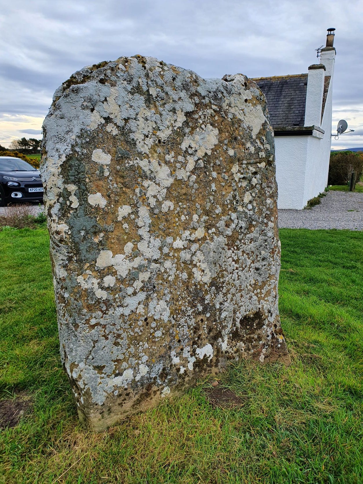
The cross-face of the Kebbuck Stone, eroded and overgrown with lichen

This is the Kebbuck Stone (see Canmore), a relief-carved cross slab dated to the 8th or 9th century, which today sits in the back garden of a cottage near Ardersier.

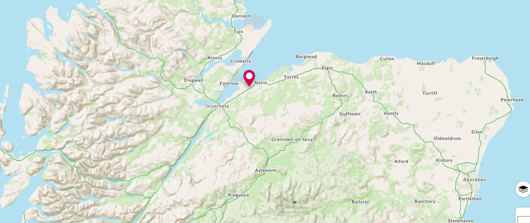
Map showing the location of the Kebbuck Stone in Nairnshire
Location of the Kebbuck Stone in Nairnshire


It’s usually overlooked in the corpus of early medieval (“Pictish”) stone sculpture because the carvings have almost completely worn away and the surface of the stone is overgrown with lichen.

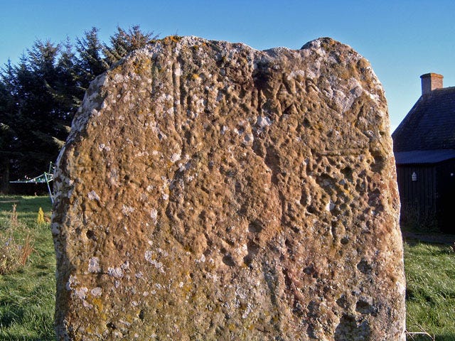
It was badly eroded even in 1893, when antiquarian George Bain wrote in his History of Nairnshire:

“The slab is very much wasted from the effects of weathering and ill-usage, but the faint outline of a Celtic cross can still be traced upon one side of it. It is a cross of the earliest form—incised and undecorated—and it would have made a most interesting memorial of early Christian times had it been better preserved.

Kebbuck Stone in evening sunlight, by Ian R. Maxwell (Geograph)
Continue reading

Etching and engraving Pictish symbols and figures on to wood

by John Wombell

The Conan Stone on wood by John Wombell see A Newly Discovered Pictish Stone for Easter Ross

First the excuse.  I tried this in the Autumn of 2019 to boost entries for the Tarradale Through Time art competition with a new interpretation of Balblair man, on a panel long since removed from a position beside Kilmorack School to Moniack Castle.  Despite being a Mercian through and through I have lived and worked in the land of the Picts for over half a century. This, as well as being married to someone with Pictish genes for sure, has led one to develop an ongoing interest in the mysterious Picts.   Living not far away, we visited the Sueno’s stone in Forres more than once with the children many years ago.

For a decade plus I had responsibility for a number of burial grounds in Kincardine and Deeside with fine Pictish stones in them (Fordoun, Tullich and Migvie). Then came one of those special moments in archaeology; when digging at Birnie I discovered the Birnie Painted Pictish Pebble and that  kept my interest going.  Stories of discovery are rarely told unless it is the likes of Tutankhamen’s tomb, and the story of the discovery of the Birnie pebble has never been told so why not now?

I had been patted on the head and set to cleaning and defining an area within what was thought to be a small Pictish house built in the ruins of a roundhouse.  What was revealed was a small setting of smooth cobbles looking like it might have been a crafting workplace.  When I first encountered the pebble it was tilted slightly on its long axis.  Fortunately that day I was in ‘careful mode’ and as soon as the top edge of the pebble was revealed it was clearly quite different and it looked like quartz or quartzite.  I left it firmly in place and carefully cleaned away another cm or so of sand from round about it. It continued to look interesting so I called over Alan Braby, who’s trench I was in, for a look see.   Alan came over, peered at the pebble, plucked it out of the sand and asked me if I had a wee brush of some kind, which I had.  Then he cleaned the pebble off and said ‘have you any idea what this is?’  ‘Haven’t a clue,’ I replied, ‘other than a finishing stone for some kind of craft work maybe’.   So then he showed me the feint decoration on the stone that was becoming clearer as the pebble dried out.  Well Alan says, ‘it is a Painted Pictish Pebble and the first to be discovered on the South side of the Moray Firth.’ Then we realised that it was decorated on both sides.   It was most exciting day.

Birnie Painted Pictish Pebble

Painted Pictish Pebbles are rare artefacts and most have been found at Caithness and Shetland broch sites.  They are at the very bottom of the Pictish art spectrum and I remain convinced that the designs on them reflect the Picts knowledge of cup and ring marked rocks, which in Pictish times would have been far more numerous than today.  Since then I have never stopped looking for blanks of the same size and shape and they are as rare as hen’s teeth.  Beach pebbles of quartz tend to be rounded and if oval they tend to be too large and too heavy.  The nearest I have found are quartzite and the replica I made of the Birnie pebble is on such a blank.  There is plenty of information on Painted Pictish Pebbles free online.

Selection of painted pictish pebbles from Shetland.

Continue reading

Barrow-Loads of Barrows: Excavating a Monumental Pictish Cemetery at Tarradale on the Black Isle

by Eric Grant

Drone aerial photo showing barrows of different sizes and shapes (Drone photo: Andy Hickie)

In the first three weeks of September 2019 volunteers from the North of Scotland Archaeological Society supported by members of the local community excavated a suspected Pictish cemetery in a field near Tarradale House. Aerial photographs had previously shown the possible existence of a number of barrow graves in the area but there was little to see on the surface as the mounds had been almost totally ploughed away but their surrounding ditches appeared as ghostly outlines on the aerial photographs. A small, but growing, number of barrow cemeteries has been identified in Scotland but only a few excavated. Aerial photographs show the remains of at least 28 square and round barrows at Tarradale making it currently the second largest burial ground of this type in Scotland. The site could originally have been more extensive as parts of it have either been ploughed out or are too deeply buried to show in aerial photographs. Recent high-resolution photographs taken by drone have suggested the existence of more barrows towards the perimeter of the field and possibly into an adjacent field. Our excavations showed that Tarradale was a barrow cemetery of monumental proportions and potentially one of the most important in Scotland.

Although we are still waiting for radiocarbon dates from the Tarradale excavation, the presence of round and square barrows and their spacing and distribution leaves little doubt that we are dealing with a Pictish cemetery potentially from the 5th or 6th century AD, an important period in the formation of early kingdoms in northern Britain. Tarradale lies in the eastern side of Ross-shire on the Beauly Firth and only six miles from Craig Phadrig, an important stronghold and regional capital in the Kingdom of Fortriu. Part of this centralisation of power was reflected in the creation of monumental cemeteries and Tarradale may have been the burial place of the local elite. No Pictish symbol stones have been found at Tarradale, although symbol stones, including cross slabs with symbols on them have been found in adjacent parishes, the nearest being the recently discovered Conan stone three miles from Tarradale. However, in the same field as the barrow cemetery, a fortified settlement was excavated in the 1990’s; no primary dating evidence for the Picts was obtained but on stylistic grounds pottery from the fortified site has been dated to between AD 300-800 so this may well be the settlement focus of some of the people buried nearby.

Plan of barrow cemetery trenches (plan by Steve Birch)

Continue reading

Droning on about Tarradale

by Andy Hickie

Drone image of Tarradale Through Time barrow cemetery dig, as featured in “Current Archaeology” November 2019.

Back in 2017, I caved in to the demands of consumerism, and purchased a new quadcopter, a Phantom 3 Advanced, which is equipped with a camera and GPS unit. I flew multiple flights around Avoch but, after a while, the novelty of seeing one’s house from the air at different angles and altitudes begins to wear thin, and I began to wonder what I could actually do with a drone. Having always had an interest in archaeology and, spurred on by seeing some of the images Alan Thompson of NOSAS had created, I decided to carry out a few experiments of my own.

My first flights took in locations such as the distillery and settlement at Mulchaich, and the features of Kinbeachie castle – sites which had already been mapped by Alan by drone, the results of which I could use as a ‘benchmark’ against which I could compare those of my own.

At the same time, I began experimenting with various flight planning apps which allow for off-line autonomous flight planning, as well as online platforms for image processing. I found that “DroneDeploy” and “Mapsmadeasy” combined provided a fairly user-friendly pipeline, whereby image capture and photogrammetry can produce georeferenced photomosaics and digital surface models (DSMs). These can then be imported into software such as QGIS for further processing.

Having found the software which satisfied my needs, I then turned my attention to potential sites which I could map – and decided on the cropmarks of the Barrow Cemetery at Tarradale. At this point, my intent was purely to satisfy my own curiosity – just to see what I could see, and how it would compare with the archaeology found at the forthcoming 2019 dig.

And so, on 10 June 2018, accompanied by my daughter Emma to act as co-pilot and “spotter”, I visisted Tarradale to map the area with the drone. I can still recall the excitement I felt as the images began to appear on the monitor of the remote controller, which showed the cropmarks were developing. However, my satisfaction was tempered somewhat when I got home and began to process the photographs. Although the cropmarks were indeed evolving, the crop was insufficiently ripe, and many of the details remained hidden (see image below).

Continue reading

Pictish Eagles and the Strathpeffer Stone

by John Wombell (NOSAS)

There are 12 known Pictish Eagle carvings, all in the RCAHMS publication of 2008 ‘The Pictish Symbol Stones of Scotland’.  They vary considerably and by far the best known and the best preserved is on the Clach an Tiompain at Strathpeffer (HER MHG43542) meaning the ‘sounding stone’ but known more widely as the Eagle Stone.

There are many images of it in circulation but a week ago I took a new set of photos which Alan Thompson kindly processed for me using photogrammetry (see images above and below, as well as on Sketchfab).  The reason behind this was that I wanted to try to produce an engraving of it on wood and needed to see more detail that is not visible to eye or touch at the stone.

The Eagle Stone has had several lumps bashed off it in the past removing part of the horse shoe symbol and the eagle’s rear end.  Otherwise damage to the carving is minimal with only part of the eagle’s leading leg either fallen or bashed off.

My dilemma was whether to give the eagle a tail or not.  I feel sure that unlike most Pictish eagles this one was drawn from a live eagle depicted walking.  It is correct in a lot of detail even though the carving is full of symbolism.  I decided to give my version a short dipped tail represented as two feathers after one of the Orkney eagles. Continue reading

A Newly Discovered Pictish Stone for Easter Ross

by Anne MacInnes

Photographs of all 4 faces of the Conan Pictish stone © HES.

Whilst on a walk close to Dingwall, I came across a site that struck me as being slightly mysterious, atmospheric and with an air of neglect about it. I was immediately fascinated, and started to try and find out more about it.

I established that it was an early religious site, privately owned, and asked the landowner if I could have permission to survey it. This granted, and because of the difficult access, I began to form a plan of just how to carry this out. A specific parking place for one car was established and the survey began.

I followed the methodology used by Susan Kruse at Kiltearn, where I had helped carry out the survey (see blog).

First of all, three of us, sectioned off the site using tapes and this enabled me to draw up plans marking all the visible stones. They were all numbered, and then surveyed and photographed in detail. Inscriptions were carefully copied on to the recording forms, which at times involved a lot of head scratching due to the worn stone. Moss was removed but not lichen as this could damage the stone. Linda helped me almost every day, with Meryl and Beth helping when they could.

The weather was kind in the winter months when this survey was done, and we were struck by the oasis of peace, emerging wildflowers and variety of birdlife with occasional visiting roe deer. A large area of ponticum and invasive sycamore was cleared with chainsaw by Terry Doe, with Linda, Kay, and myself dragging it offsite. Finally a group of nine NoSAS members planetabled the site and did levels to show the footings and platform of a chapel, and Meryl drew this up.

The survey revealed as well as the probable chapel footings, upright headstones in various shapes and sizes, lair markers, tabletombs, graveslabs, some lightly covered by moss.

Most of them looked like this, either blank or with initials carved at the top. All the stones were orientated with their carved faces towards the east.

One day, I was brushing off leaves from a graveslab sitting on the ground, not buried, when I  noticed a bit of carving that looked like a foot. Carefully removing a bit more, a leg was attached to this foot! I couldn’t believe what I was seeing, so much so that I went to do something else and ignored it. However on my return it was still there and more was revealed. Continue reading

A Year of Highland Archaeology

by James McComas (NOSAS)

A Year of Highland Archaeology book cover, showing Tarradale Through Time excavation trench with the settings of a possible stone hut. The same trench yielded several rare antler tools.

NOSAS has just published A Year of Highland Archaeology: A Collection of the Projects and Activities of the North of Scotland Archaeological Society . This new book includes 10 articles which explore some of the diverse recent projects that we has been involved with. These range from large scale funded excavations through to group surveys and small scale research projects. They highlight Highland locations from the west to the east coast, from Speyside to Sutherland.

Projects featured include the lottery funded Tarradale Through Time Project, which in 2017 saw 6000 year old antler tools uncovered near Muir of Ord on the Black Isle.  These very rare finds included the remains of a harpoon point and two “T axes” left behind by hunter gatherers on the shores of the Beauly Firth. The T axes are two of only five examples so far known in the whole of Scotland. The trench where these were found also tantalisingly revealed the possible stone setting of a Mesolithic hut. Tarradale Through Time continues in Autumn 2019 with the excavation of potentially one of the largest barrow cemeteries in Scotland (further information at www.tarradalethroughtime.co.uk).

One of rare antler “T axes” found during Tarradale Through Time’s 2017 excavations.

Another chapter focuses on Torvean Hillfort, a neglected structure on the edge of Inverness. Torvean was perhaps constructed more than 2000 years ago, but it is today sadly under threat from persistent trail bike damage. A different chapter tells the much more positive story of how a collection of 400 historic maps relating to the Lovat Highland Estates, covering extensive areas west of Inverness, have now been scanned and made available online.

Map of Torvean Hillfort, Inverness showing destructive trail bike tracks

A different chapter still focuses on the NOSAS’s work with Scotland’s Rock Art Project. ScRAP aims to log as many as possible of the mysterious carved “cup marks” which appear on Scotland’s boulders and rock faces over a 5 year project. The precise date of these carvings, of which there are many good examples in the Highlands, is unknown but they are thought to have been mainly created in the Neolithic period around 6,000 to 4,000 years ago. Other archaeological locations explored in the book include Ormond Castle in Avoch, a prehistoric roundhouse landscape in Glen Urquhart, and Gruinard Island in Wester Ross.

3D Photogrammetry model of cup marked stone at Kinmylies, Inverness

Continue reading

Experimental Archaeology: Learning about Technologies in the Past

by Susan Kruse (ARCH and NOSAS)

Thanks to funding from Historic Environment Scotland and the Heritage Lottery Fund, ARCH launched an exciting project ‘Experimental Archaeology: Learning about Technologies in the Past’ in October 2017. The project had three main strands. In the first year, 13 experimental archaeology days and 10 school visits took place where craftspeople demonstrated and explained different technologies used in the past. The workshops were filmed and the edited videos and blogs for each workshop can be accessed on the ARCH website.

Jim Glazzard at the Viking ring silver workshop

In the second year, the objects resulting from these workshops will then be used to create loans boxes which will be freely available to borrow. Our workshop leaders often generously provided more than one object. An archaeologist and teacher will now work together to create learning materials, so that the loans box and videos of the experimental sessions can be used in schools and other groups. The project already has attracted a wide and diverse audience, and we hope that the loans boxes will also contribute to this legacy.

The idea for the project emerged from North Kessock & District Local History Society’s Feats of Clay project, where ARCH helped facilitate a visit by Neil Burridge who demonstrated Bronze Age metalworking. Everyone in the audience was caught up in the excitement of the day, and learned so much about how objects were made, what raw materials were needed, and how craftsmen in the past managed without gauges and modern equipment.

Neil Burridge at the Bronze Metaworking workshop

In the first year 13 workshops took place, one a month, each showcasing a skill from the past, spanning from earliest settlers to more recent times. The workshops were exciting to attend, but were also filmed. Continue reading