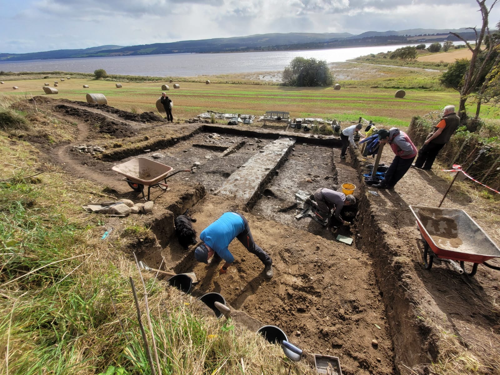
In 2017 the Tarradale Through Time project excavated a shell midden (known as site 2B) located on a raised beach terrace at the foot of a palaeo-cliff about 150 m south-east of Tarradale House, see previous blog post. In September to October 2023 the site was revisited by the Tarradale Archaeological Team in order to continue the earlier investigation. The original 2017 excavation trench was approximately 8 m x 6 m and revealed a complex sequence of marine shell midden deposits comprising mussel, cockle, periwinkle, oyster, whelk along with animal and fish bones. A number of possible struck quartz flakes and worked flint was also found within the midden but compared with shell midden excavations in other parts of Scotland, site 2B was lithic poor. Several significant worked bone and antler artefacts were recovered from the shell midden including the remains of two antler T-axes and a fragment of a biserial antler harpoon.
2023 excavations in Trench 2B
A series of radiocarbon dates from the 2017 excavations gave results between 4832 and 3643 cal BC. This range of more than 1000 years suggests that the site had been occupied, if not continuously, at least regularly, from the Mesolithic into the early Neolithic period. A number of stone settings was found within the excavated area and on the east side of the trench an underllying spread of cobbles and sandy gravel was interpreted as the original raised beach surface. Owing to lack of time in 2017, the western side of the trench was not excavated to the same depth, so the excavations in 2023 had the primary objective of removing the remaining shell midden deposits and evaluating the underlying deposits and any potential structures. It is apparent that the shell midden site had been disturbed through the ages by agricultural activity forming rig and furrow and the only reason that site has survived to the present is that it is bounded on one side by a fence and on the north by the palaeo-cliff, making it impossible for larger agricultural machines to plough the area. If this had not been the case the site would have been totally destroyed. Indeed, a considerable area to the south of the surviving site has been severely truncated by ploughing.
When I first started looking at the site of the Saltwater Mill at Petty Bay, I was writing a general survey of industry in Petty Parish (2019). I discovered that there was very little primary evidence for the mill and access to the site was not easy. In fact, at the time, I couldn’t see how to get down to the site, since the Castle Stuart Golf Course had taken over the area to the north of the Church and fenced the course in. It was only when Scape visited in 2022 that I finally managed to see for myself exactly where the mill had been situated. At that time information about the mill was limited and much came from secondary sources. As a result there wasn’t a clear picture of what it had been like. Sources highlighted the double waterwheel and the fact that it operated on both incoming and outgoing tide. There was also the suggestion that it may have been built Cromwell’s time. But nothing of the mill building has survived, and only the remains of the bulwark which enclosed the mill dam at the eastern end of Petty Bay indicates that this feature, known as one of the wonders of the parish, ever existed. However, during the last year a number of sources have been uncovered and these have added to our sum of knowledge and fleshed out the picture of the mill and the surrounding area.
Site of the Saltwater Mill, 2023. The fence posts indicate the line of the bulwark and the members of NOSAS are standing close to where the mill building would have been.
There’s no evidence to support the idea that it was built as early as Cromwell’s time, but the evidence does suggest that it did have a double wheel and that it operated on both outgoing and incoming tide.
In the Moray Estate archives there’s a building contract dated 1673, which fixes the date of construction –
ane salt water milln at the [Kenōger] of Castle Stewart within the sea marke of the lenth breadth and hight and other conditions as folloves videlicet the said milln to consist in breadth of threttie sex foott in measur within walls sexteine foott of breadth and tenn foott hight from the floor of the said millne when the samen is in la[v]ell. The lavell [that be] is nixt the water to be of asler werke without tuo foott above the vater wheel and also the wheel postes within and without bothe sydes to be of the same as it reguards others postes and to be mented with flages under the inner and utter wheels, according as it shall be neidfull. As also shall three hewen doors wherof on is to be in the north gavell with ane sufficient stair leading therto with fyve windows and more if it be required and also the said Robert is heirby obliged to big the water wheel gaits of the said mill dame with asler werke untill the samen be suffiecent done and the cluse of the said milln is to be biged in the same forme with asler stone.
Transcript by C.McLaren
This contract gives some very useful detail. The internal size is specified at 36’ (10.97m), by 16’ (4.87m), by 10’ (3m) high. The mention of the ‘inner and utter wheels’ confirms that there were two waterwheels placed in parallel, and there were three doors, one in the north gable with a stair leading to it, and at least five windows. There’s also mention of ‘water wheel gaits’ and a sluice (‘cluse’). But this contract with Robert Niklesone, the mason at Cawdor, says nothing of the roof, or the machinery which would be needed, so it’s probably only one of several contracts with local craftsmen which have since been lost.
We can only surmise as to what the building looked like. The estate map of 1808 shows it as a rectangular building at the northern end of the bulwark, but 10’ in height doesn’t seem to be high enough to accommodate the machinery necessary, so it may be that a wooden superstructure was added. What we may have here is a contract for the base of the building in stone, probably because it was sitting at or near the high tide line. The requirement for ‘aslar [ashlar] stone’ suggests that it was good quality and looked a very fine building. The roof would have been thatched, but may have been slated in the C18.
A mill dam was constructed by building a dyke or bulwark across the eastern end of the bay and this feature is mentioned in Tours in Scotland, 1677 and 1688 by Thomas Kirk and Ralph Thoresby:
We crossed a bank by a mill, near Stewart Castle, a quarter of a mile over, in the middle whereof were a pair of flood-gates, whereby the dam was filled with the tide, and supplied the mill at low water.
This ‘bank’ is all that remains on the ground and Tom Watson’s aerial shot of the area (below), taken in 2022 when Scape visited the site, shows the remains with what looks like a stone-lined pit for the water-gates over the mouth of the Rough Burn.
From the written evidence of secondary sources and maps on the maps.nls and Scotlandspeople websites
by Meryl Marshall
Background
In the years before the 18th Century the Highlands were regarded as a hostile backward country, travelling was difficult, there were few visitors and many journeys were made by boat. In 1793 George Brown reported that,
The most necessary and useful line of road betwixt East and West Sea through the four Northern Counties of Scotland […] is a line across the county of Ross from the town of Dingwall on the head of the Cromarty Firth, to Poolewe on the west coast by Contin, Strath Garve, Kanloch Laygart, Strath Brain and Caimsey to the junction of the river of Ew with the sea. Here the Lewis packet boat passes and it is the great line of communication to Inverness, Dingwall and […] that part of the coast which abounds with valuable fishing lochs. At a place called Auchnasheen a branch should break off and go westwards to Loch Carron and at Kenloch Ew another branch should turn off to Loch Torridon.
General Report H R & B 1803
In 1772, Pennant writes that Poolewe “is the station of a government packet that sails regularly from hence to Stornoway in Lewis […]This is a spot of much concourse; for here terminates the military road which crosses from the east to the west sea” (1998 p333). Over the years this route has seen many changes. Today the area around Gairloch and Poolewe is well known for its outstanding scenery and is frequented by a multitude of holiday visitors, some even choosing to spend their retirement here. This account explores the checkered history of the route.
Poolewe to Achnasheen – Johnson 1834
Haldane writes that there are “authentic records of a regular post to Lewis in 1756” (Haldane 1971 p175) and Dixon has “the post runner came from Dingwall by Strath Braan and Glen Dochartie to the head of Loch Maree then along the east (north) side of the loch via Letterewe to Poolewe”, coming “to Poolewe on Wednesdays and Saturdays walking “through the Rock” ie Bull Rock” (Dixon 1886 p147-148).
In 1786 John Knox reports that he had sailed from Stornoway to Poolewe in a small unseaworthy vessel used for the transport of cattle (Haldane 1997 p107). From the early 18th century the export of cattle was important to the Highland economy. The beasts reared in the Outer Isles of Lewis and Harris were shipped from Stornoway to Poolewe before being “driven” south to the markets of Crieff and Falkirk. The New Statistical Account of 1845 for Stornoway records that near the town, “there is a square mile of moor enclosed for a cattle tryst where several thousand head are exposed for sale and at least 2,000 change hands in 2 days; from 20 to 30 drovers come from the Mainland and some from England”.
The First Road
Following the risings of 1715 and 1719 the Government undertook the construction of a network of roads to facilitate communications throughout the Highlands and suppress the Highland rebels. The project was supervised initially by General Wade and then until 1767 by Major William Caulfeild. The labour force was provided at first by the military and in later years, when the budget was reduced, by unskilled labourers (Haldane 1962 p8-9). The Dingwall/Poolewe road, built c1763-1768, was one of the later roads. The course of the road is marked on maps of 1793 and 1811 ( RHP11597, RHP11674 and RHP11675)and annotated “old road”(see Scotlandspeople website).
RHP11674 Plan of proposed road between Achnasheen and Loch Maree 1811Continue reading →
Petty Bay lies approximately 5 miles east of Inverness. Today it’s bypassed by the A96, but a map of 1798 shows that the original road from Inverness to Ardersier and Fort George looped off the Inverness-Nairn route at Allanfearn and joined the present B9039 at Castle Stuart Farm. The 1st edition 25” Ordnance Survey map indicates a track running down between Castle Stuart and Castle Stuart Farm, and following the coast out to the point.
The area was clearly much busier than it is today.
The Old Statistical Account (OSA) notes that there are no harbours in this area of the Moray Firth, but
there are two or three places within this parish [Petty] where safe and commodious harbours for small vessels might be made at a small expense.
One of the places was Petty Bay, and goods were often unloaded there to avoid the shore dues in Inverness. Adverts in the local press encouraged this practice. Winter’s map of 1760 highlights this by drawing three sailing vessels in the bay. In addition to the commercial and foreign trade activity, there were fishing communities along the coastline of Petty Parish, from Alturlie Point to Ardersier. Evidence of all this activity can be found round the Bay and these have been recorded by SCAPE – a stone alignment which may be a slipway at Alturlie Point (15433); a possible jetty at Clattach (15487); a stone alignment which may be a fish trap to the east of Alturlie Point (15432); pier posts and fishing structures at Newton of Petty (15455).
Remains of boat at east end of Petty Bay, 2022
In addition there’s evidence of abandoned boats around the bay. At Clattach, SCAPE records a ballast mound which may be part of a boat graveyard (15466) and there are the remains of a wooden clinker-built fishing boat at Lonnie (15464). There are also several ballast mounds and decayed timbers at the eastern end of the Bay.
It took two more days of work in August to clear the remaining gorse scrub off the cairn to reveal the monument in its glory. With funding from Historic Environment Scotland we were able to get contractors to shred much of the cut waste, though a substantial amount of gorse remains outside the cairn on the east side.
We were fortunate to get Andy Hickie to fly his drone over the cleaned monument and as the photo above shows, this highlights the prominent position of the cairn overlooking the Moray Firth and with views to the hills north of the Great Glen and south to the Monadhliaths. This view is largely obscured by modern conifer plantations today but it now shows the significance of the monument’s siting in Neolithic times. No new details on the construction of cairns were visible on the ground in addition to that previously recorded by Henshall and Ritchie, but skilled processing of his aerial images by Andy Hickie has revealed the profile of this monument. (See also the recent Current Archaeologyarticle on Carn Glas, featuring Jonathan’s text and Andy’s images. A transcription of the text from Henshall & Ritchie can be downloaded here).
Investigating a possible crannog at Loch Morie, June 2023
Almost three years has passed since the inception of the NOSAS Crannogs project, one sunny post-lockdown afternoon sitting around my patio maintaining a 2-metre separation, unable to meet inside but mightily pleased to be chatting face to face instead of by zoom. Who had even heard of zoom before lockdown? We hatched a cunning plan – to search satellite images for islands which might prove to be unrecorded crannogs. Surely there must be lots of them, secreted away in remote glens where archaeologists rarely tread? Well, no, actually.
Movement was still restricted so there was no shortage of volunteers, happy to have something different to do at home, and we soon had plenty of islands to look at in the field. Some were explored in 2022 but by the start of 2023 we had a shortlist of very promising looking targets which certainly looked like crannogs from the shore. They would need snorkelling or diving around to check out their underwater credentials to be sure whether they really were artificial constructions. There was also the Loch Achilty crannog, which had been dived and surveyed in 2022 and where timbers had been found which could potentially be radiocarbon dated (see previous blog posts here and here).
Aside from crannogs, but continuing the underwater theme, I had spent two weeks in 2022 diving HMS Natal in the Cromarty Firth as part of a Nautical Archaeology Society project. So it was that Claire Hallybone from NAS came up to present the findings of the Natal project at a NOSAS “MAD” evening (that’s Monthly Archaeological Discussion for the uninitiated) and also to dive some real and potential crannogs with me.
It was early March and whilst the weather was conducive to a jolly evening chatting in Strathpeffer Hall, for diving – not so much. Nevertheless, we braved a chilly Loch Achilty and were successful in obtaining a timber sample from the shallower of two embedded timbers. It was surprisingly hard work. I made two parallel sawcuts in the edge of the wood and then tried to chisel out the bit in between with my knife but the wood was so hard I broke the tip off my knife. Eventually the sample was obtained but it took about 40 minutes, by which time we were shivering with cold and both agreed one dive was enough for the day and the second, deeper timber would have to wait for another time.
Loch Achilty crannog: This timber was radio carbon dated to c. 1359 AD, and another to c. 1060 AD (Duncan Ross)Continue reading →
Over the last twenty years I have thoroughly enjoyed tramping around Assynt, sometimes on my own and sometimes with groups of friends. That sense of enjoyment is often enhanced by surprises. It might be disturbing a mountain hare and seeing it race away at speed or watching an overhead confrontation between golden and white-tailed eagles, but those events have been rare. More frequently the surprises have been coming across all sorts of unrecorded archaeological sites. A classic example happened about 10 years ago when a small group of NOSAS and Historic Assynt members set out to look for rock art in Assynt and after several days of searching, completely failed to find so much as a single cup mark! But the effort was rewarded with several surprises – an iron working site, a roundhouse, a chambered cairn and at least one smaller cairn with signs of a cist in the centre, none of which had been recorded.
Assynt has a relatively dense cluster of cairns concentrated in and around the valley that links Ledmore Junction and Inchnadamph. Many of them were recorded long ago and described in detail in Henshall (1963, 1972) and Henshall and Ritchie (1995). However, in recent years finding ‘new’ cairns in the same area has become almost normal, but no less exciting! Overall numbers have now almost doubled to at least 30 chambered cairns and 14 smaller round cairns. The Assynt cluster is now one of the largest concentrations known anywhere in Scotland and the numbers continue to increase. The best preserved are now all scheduled and the scheduling highlights the fact that these are all part of a significant cluster. This high survival rate, which applies to other archaeological sites in Assynt, is most probably because the area has always been sparsely populated with little intensive farming or other forms of large-scale development.
Bad na Cleithe chambered cairnRecently discovered chambered cairn, 500m from Bad na Cleithe CairnContinue reading →
This remote loch is far from any normal vehicular access. The boundary between Attadale and Pait estates runs roughly SW-NE through the middle of the loch. Approach routes to the loch are from Pait on Loch Monar to the NE, Attadale towards the head of Loch Carron in the W, and Killilan via Strath Duilleach and the Iron Lodge to the SW. There are three islands in the loch, two of which are of interest.
OS maps showing location of Loch Tachdaidh
Historic Environment Scotland’s Canmore (ID 12075) and Highland Council Historic Environment Record (MHG44808 [Causeway] & MHG7444 [the island itself]) both describe the same features of a possibly artificial island in the southern part of Loch an Cladaidh. It is linked to a promontory on the south shore by two causeways to the SW and the NE.
The two historical references to this possible crannog are:
Odo Blundell’s 1913 paper: Further Notes on the Artificial Islands in the Highland Area. PSAS, vol XLVII, p 281:

The Gead Loch. He quotes correspondence with a local minister, the Rev. D. Mackay, Marydale, Strathglass who reports: “In this loch, which is just across the boundary between Ross-shire and Inverness-shire there are two entirely artificial islands, one of them with an evident causeway to the shore”.

Ordnance Survey visit by (NKB) 24th October 1966:

There are no crannogs on An Gead Loch, but at NH 0955 3797 about 15.0m from the S shore of Loch an Tachdaidh, there is a natural island 40.0 by 26.0m and 2.0m high, connected to the mainland by a well-defined causeway 3.5m. wide and protruding about 0.2m above the surface. There are no structures on the island.
As described above, Blundell recorded local knowledge of two crannogs in 1913 in An Gead Loch, which the OS names as the loch just to the north-east of Loch an Tachdaich, separated from it by a short river. However, local tradition calls all three lochs here “The Gead Lochs”. There are no potential crannogs in the OS’s An Gead Loch, so it is fair to assume that the islands in Loch an Tachdaidh are the ones to which Blundell refers.
The 1966 OS survey report states that the island 15m from the south-east shore is natural but the causeway to it is man made. After investigating it, that is our conclusion too. The island towards the SE shore of the loch is centred at NH 09580 37988, with two causeways:
Looking NW across Loch an Tachdaidh from the shoreline track. Note the proximal island we investigated. Of the two distal islands, the other potential crannog is on the R (Glenn Wilks).Continue reading →
The gorse covered mounds of Carn Glas on the skyline looking south west with a ploughed out roundhouse site in the foreground.
Background
In early march NOSAS members helped clear part of the gorse scrub encroaching onto the major Neolithic Cairn Carn Glas (Grey Cairn NH 6493 3830) sited on Essich Farm in Stratherrick above Inverness. Sitting on a shallow saddle-shaped ridge on Essich Moor and overlooking the Moray Firth to east, the three interlinked cairns that form this monument make this, at 116 metres, the longest in the Highlands. Though now obscured by a modern forestry plantation, it is in a commanding position looking down the Moray Firth. For comparison the better known and partially reconstructed Camster Long Cairn in Caithness, itself comprising two round cairns, measures just under 70 metres in length. This relative scale of the two cairns can be seen in the plans below drawn for Audrey Henshall’s Chambered Cairns of Scotland, where Camster is the second and Carn Glas the fourth image.
History of the site
The cairn lies on farm of Essich, one of the major tacks or holdings of the Mackintosh family with references to the land at least back to the 16th century.
The cairns at Carn Glas have been heavily robbed and the chambers emptied, probably as a source for stone dykes and other agricultural improvements dating to the late 18th and early 19th centuries. V Gordon Childe in 1943 suggested stones may have been taken from here to build the section of the Military Road (built from 1725) that lies to the west and runs towards Loch Ashie.
The first known mention of the cairn itself is on a sketch plan of the farm by an unknown surveyor dating to 1834. Forming part of the muniments of the Mackintosh of Mackintosh family, it is stored with other documents dealing with Essich in the National Archives in Edinburgh.
Crown copyright. Papers of the Family of Mackintosh of Mackintosh, National Records of Scotland, RHP2187
The surveyor has probably (the text and image here are a little obscure) described the site as:
Glaischcairnmore so-called
a collection of stones on the summit of three hillocks
He has also shown three separate cairns, the easternmost and still most prominent today, is labelled Cairn. There is a suggestion of four stones ringing the middle cairn but other details are obscure. However it does seem the site had already been heavily robbed by this time. The wider plan shows the boundary of the farm defined by a row of boundary stones some of which still survive today and date to 1794 suggesting this was a time of major works on the farm when stones for dykes and buildings might be needed.
Does every excavation and discovery have a story behind it? Maybe. This one certainly does. When did the story start? With shepherds moving into empty land in the early 19th century? With the gradual depopulation of Highland glens in the early half of the 20th century? With the construction of the largest dam in Scotland completed in 1952?
Maybe it’s best to start this story in early July 2021 with a walker and cyclist, Glenn Wilks, venturing into the remote west end of Loch Mullardoch. This large reservoir loch was created from two previous lochs, Lungard and Mullardoch, when a dam was built in upper Glen Cannich flooding the upper glen for a distance of 15km. The dry summer of 2021 produced unusually low water level in the loch, exposing kilometres of bare sand and gravel at its western end. The walker, Glenn, noticed that the now exposed reservoir bed contained several circular stone structures. Although he wasn’t an archaeologist, he recognised that these were special and so took photographs and videos as a record of what might soon be covered up by the water again.
One of hut circles exposed by the low waters of the loch (Glenn Wilks)
Once he was out of the glen, he contacted Historic Environment Scotland with the information and photos. A serendipitous encounter between one of the HES officers and the author in Beauly soon after this, ended with the officer sharing the knowledge of this new find. Fortunately, the author had himself been to this area before, on a walking trip in 2014 when the water level in the reservoir was much higher. So, he knew the area and the difficulty of access, and yet was enthused at the prospect of investigating these features.
Modern OS Map showing length of Glen Cannich and Strath Glass (OS)Map of Lochs Lungard & Mullardoch before the Mullardoch Dam (OS)Continue reading →