Category Archives: Excavations

Mesolithic Encounters: Tarradale Shell Midden Excavation, Autumn 2023

by Eric Grant

2023 excavations in Trench 2B

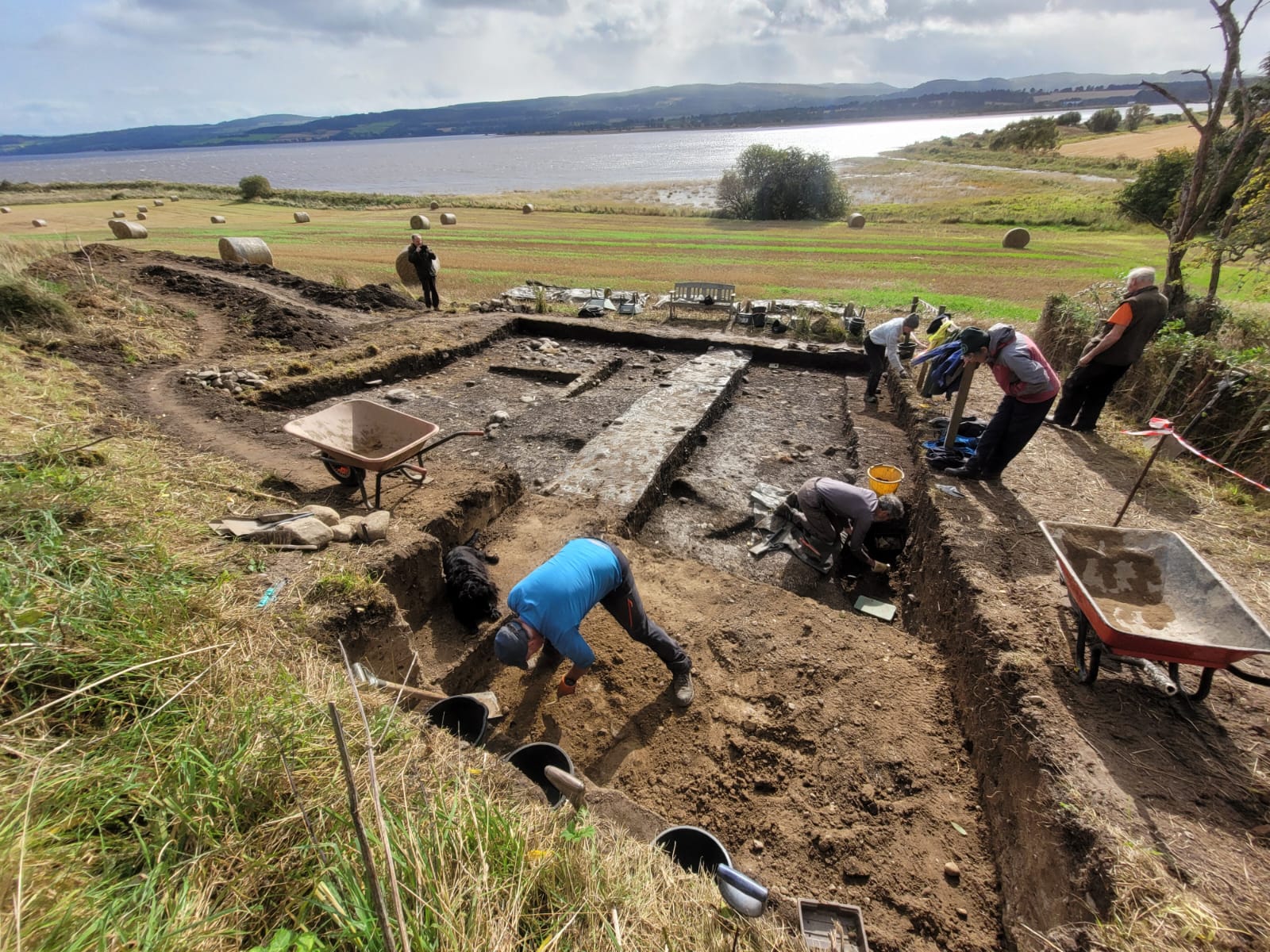
In 2017 the Tarradale Through Time project excavated a shell midden (known as site 2B) located on a raised beach terrace at the foot of a palaeo-cliff about 150 m south-east of Tarradale House, see previous blog post.  In September to October 2023 the site was revisited by the Tarradale Archaeological Team in order to continue the earlier investigation. The original 2017 excavation trench was approximately 8 m x 6 m and revealed a complex sequence of marine shell midden deposits comprising mussel, cockle, periwinkle, oyster, whelk along with animal and fish bones. A number of possible struck quartz flakes and worked flint was also found within the midden but compared with shell midden excavations in other parts of Scotland, site 2B was lithic poor. Several significant worked bone and antler artefacts were recovered from the shell midden including the remains of two antler T-axes and a fragment of a biserial antler harpoon.

2023 excavations in Trench 2B

A series of radiocarbon dates from the 2017 excavations gave results between 4832 and 3643 cal BC. This range of more than 1000 years suggests that the site had been occupied, if not continuously, at least regularly, from the Mesolithic into the early Neolithic period. A number of stone settings was found within the excavated area and on the east side of the trench an underllying spread of cobbles and sandy gravel was interpreted as the original raised beach surface. Owing to lack of time in 2017, the western side of the trench was not excavated to the same depth, so the excavations in 2023 had the primary objective of removing the remaining shell midden deposits and evaluating the underlying deposits and any potential structures. It is apparent that the shell midden site had been disturbed through the ages by agricultural activity forming rig and furrow and the only reason that site has survived to the present is that it is bounded on one side by a fence and on the north by the palaeo-cliff, making it impossible for larger agricultural machines to plough the area. If this had not been the case the site would have been totally destroyed. Indeed, a considerable area to the south of the surviving site has been severely truncated by ploughing.

Trench extension to the NW shown in the foreground
Continue reading

Cairns in Clusters: Chambered Cairns in Assynt

By Gordon Sleight

Carrachan Dubh chambered cairn near Inchdnadamph

Over the last twenty years I have thoroughly enjoyed tramping around Assynt, sometimes on my own and sometimes with groups of friends.  That sense of enjoyment is often enhanced by surprises.  It might be disturbing a mountain hare and seeing it race away at speed or watching an overhead confrontation between golden and white-tailed eagles, but those events have been rare. More frequently the surprises have been coming across all sorts of unrecorded archaeological sites. A classic example happened about 10 years ago when a small group of NOSAS and Historic Assynt members set out to look for rock art in Assynt and after several days of searching, completely failed to find so much as a single cup mark!  But the effort was rewarded with several surprises – an iron working site, a roundhouse, a chambered cairn and at least one smaller cairn with signs of a cist in the centre, none of which had been recorded.

Assynt has a relatively dense cluster of cairns concentrated in and around the valley that links Ledmore Junction and Inchnadamph.  Many of them were recorded long ago and described in detail in Henshall (1963, 1972) and Henshall and Ritchie (1995). However, in recent years finding ‘new’ cairns in the same area has become almost normal, but no less exciting! Overall numbers have now almost doubled to at least 30 chambered cairns and 14 smaller round cairns.  The Assynt cluster is now one of the largest concentrations known anywhere in Scotland and the numbers continue to increase.  The best preserved are now all scheduled and the scheduling highlights the fact that these are all part of a significant cluster. This high survival rate, which applies to other archaeological sites in Assynt, is most probably because the area has always been sparsely populated with little intensive farming or other forms of large-scale development.

Bad na Cleithe chambered cairn
Recently discovered chambered cairn, 500m from Bad na Cleithe Cairn
Continue reading

Kinellan Crannog, Strathpeffer

by John Wombell

Loch Kinellan, Google Earth 2015.

A few notes on Kinellan Crannog for crannog enthusiasts.  We are fortunate to live at Kinellan, about 400m away from the crannog as the crow flies.  In February this year Kinellan Loch froze over to a depth of 10” and we had days of glorious sunshine when local families were taking their lockdown exercise out on the ice, and we spent an afternoon on the crannog taking photos and  chatting to neighbours and their children. About 15 years ago I remember leading a NOSAS visit out to the island during another big freeze.

Kinellan Crannog taken from the south shore looking north, February 2021.

Some years ago 4 NOSAS members obtained permission from Historic Scotland and the owner to remove some fallen willow that had tumbled into the loch on the south side, in order that locals and visitors could see from the shore track the Medieval stone work surrounding most of the artificial island.  That was two days of very hard work, hand winching fallen trees back out of the loch then cutting them up.   Seeing young children exploring the island this February made me wonder whether the crannog was ever a family home with children playing or had it always been a male dominated stronghold.

Fraser’s 1916/17 report of the 1914/15 and 16 excavations was published in the PSAS and is available online. It is compulsive reading and I shall not spoil it for you by delving too far into the report.  Mr Fraser was a teacher in Dingwall and was only able to supervise the excavations part time and during school holidays.  With WW1 raging he had difficulty finding workmen but he eventually found two local men and all work appears to have been done with spades.  There is no mention of trowels.  He did however engage a Dingwall architect to make measured drawings and another teacher to make sketches.   A third person undertook the photography.  Fraser was as thorough as he could be at that time and he records a lot of detail.  I do not know whether there is an official archive stored away somewhere but a century on I think an updated expert re-interpretation of Fraser’s work would be a good starting point for new research.

The last known use of the crannog was as a kitchen garden and orchard by the tenant of Kinellan Home Farm in the late 19th and early 20th C.  A thicket of old fruit tree rootstock scrub still survives and few tangled gooseberry bushes.  Today though the crannog is dominated by dense mature ash and willow trees, an occasional gnarled Hawthorn and two very fine birch trees.  Many of the willows have fallen down, most are dead and rotting away but a good number, especially those that have tumbled into the loch remain alive and have produced masses of new stem growth called Phoenix growth – raised from the dead!

Continue reading

Barrow-Loads of Barrows: Excavating a Monumental Pictish Cemetery at Tarradale on the Black Isle

by Eric Grant

Drone aerial photo showing barrows of different sizes and shapes (Drone photo: Andy Hickie)

In the first three weeks of September 2019 volunteers from the North of Scotland Archaeological Society supported by members of the local community excavated a suspected Pictish cemetery in a field near Tarradale House. Aerial photographs had previously shown the possible existence of a number of barrow graves in the area but there was little to see on the surface as the mounds had been almost totally ploughed away but their surrounding ditches appeared as ghostly outlines on the aerial photographs. A small, but growing, number of barrow cemeteries has been identified in Scotland but only a few excavated. Aerial photographs show the remains of at least 28 square and round barrows at Tarradale making it currently the second largest burial ground of this type in Scotland. The site could originally have been more extensive as parts of it have either been ploughed out or are too deeply buried to show in aerial photographs. Recent high-resolution photographs taken by drone have suggested the existence of more barrows towards the perimeter of the field and possibly into an adjacent field. Our excavations showed that Tarradale was a barrow cemetery of monumental proportions and potentially one of the most important in Scotland.

Although we are still waiting for radiocarbon dates from the Tarradale excavation, the presence of round and square barrows and their spacing and distribution leaves little doubt that we are dealing with a Pictish cemetery potentially from the 5th or 6th century AD, an important period in the formation of early kingdoms in northern Britain. Tarradale lies in the eastern side of Ross-shire on the Beauly Firth and only six miles from Craig Phadrig, an important stronghold and regional capital in the Kingdom of Fortriu. Part of this centralisation of power was reflected in the creation of monumental cemeteries and Tarradale may have been the burial place of the local elite. No Pictish symbol stones have been found at Tarradale, although symbol stones, including cross slabs with symbols on them have been found in adjacent parishes, the nearest being the recently discovered Conan stone three miles from Tarradale. However, in the same field as the barrow cemetery, a fortified settlement was excavated in the 1990’s; no primary dating evidence for the Picts was obtained but on stylistic grounds pottery from the fortified site has been dated to between AD 300-800 so this may well be the settlement focus of some of the people buried nearby.

Plan of barrow cemetery trenches (plan by Steve Birch)

Continue reading

The Archaeology of the Findhorn Dunes

by Michael Sharpe

Findhorn Dunes Site from the NE. In the upper left is the caravan park, and beyond the Cromarty Sutors.

Introduction

This story begins back in 2002 or so, when during a conversation about local history and archaeology, a local farmer and digger driver I had worked with mentioned to me that he knew of a site in the dunes east of Findhorn Village, Moray, where people had found flint in the past (Figure 1). I decided to go and have a look, and before long was finding not only flint tools and debitage, but also pot sherds, beads, fragments of copper alloy, and the remains of a midden. It is likely that this is the site of a flint scatter and old land surface (OLS) reported by Ian Shepherd (1977) and recorded on the Moray Sites and Monuments Record (NJ06SE0010 – Findhorn), although there is a discrepancy of 0.5km as to location. He probably wouldn’t have had even a basic GPS unit at his disposal, and it’s difficult to accurately pinpoint locations among the dunes.

Fig. 1 Location map

What follows is summary of the results of 15 years of surface collecting of finds, and recent efforts to investigate the site more systematically: namely a few test pits in 2016, but mainly a weekend of work in 2017—an informal dig staffed mostly, if not entirely, by NOSAS members. Permission for the collecting and minimal digging was given early on by the Findhorn Dunes Trust, which has a duty of care for the land surrounding the site.

Shore section showing eroding old land surface. The figure is standing on top of the east dune.

The local archaeological context

I won’t attempt an exhaustive summary of the archaeology of the area, as there are many good publications that do that, including numerous papers in the Proceedings of the Society of Antiquaries of Scotland. Suffice it to say that broadly, within the coastal lowlands of the south Moray Firth coast, there is ample evidence of prehistoric occupation from the Mesolithic onwards. This ranges from Mesolithic and Neolithic arrowheads at Culbin; numerous Bronze Age (BA) cist burials, such as those at Burgie Lodge Farm near Rafford, one of which contained a jet necklace (Callander 1916); and larger BA burial monuments, such as the Clava Cairns near Culloden. As at Rosemarkie, there are numerous caves on the coast between Hopeman and Lossiemouth where excavations—most recently by Ian Armit—have found evidence of occupation from the Mesolithic onwards, including BA burials, and the remains of decapitated individuals from the IA. Excavations by Fraser Hunter at Birnie—south of Elgin—and at Clarkly Hill near Burghead revealed IA farming settlements on the productive farmland of the coastal lowlands, and also evidence of probable contact with the Romans.

Findhorn and its immediate surroundings have offered up: a BA hoard containing two spear-heads and a socketed axe (Callander 1920); a rich BA burial from Findhorn Village in which a large cinerary urn contained the cremated remains of a young woman and a neonate as well as a substantial number of faience beads, a rare find in the UK (Shepherd and Shepherd 2001); and the remains of two cremated individuals among the dunes east of the village (Black 1891).

Bradley et al. (2016) have proposed the new site type of Maritime Havens: areas which developed early on after the Pleistocene Ice Age, and which went on to become centres of trade and industry, with extensive links across both water and land. The exceptional quantity of artefacts found at Culbin Sands during the 17th to 19th centuries led him to propose that the Culbin Sands was one such haven. Due to its proximity, the people using the Findhorn Dunes Site were likely connected with this activity. The one artefact type which connects this dunes site, the Findhorn burial, and Culbin Sands also happens to be one of the rarest—faience beads. Continue reading

A Year of Highland Archaeology

by James McComas (NOSAS)

A Year of Highland Archaeology book cover, showing Tarradale Through Time excavation trench with the settings of a possible stone hut. The same trench yielded several rare antler tools.

NOSAS has just published A Year of Highland Archaeology: A Collection of the Projects and Activities of the North of Scotland Archaeological Society . This new book includes 10 articles which explore some of the diverse recent projects that we has been involved with. These range from large scale funded excavations through to group surveys and small scale research projects. They highlight Highland locations from the west to the east coast, from Speyside to Sutherland.

Projects featured include the lottery funded Tarradale Through Time Project, which in 2017 saw 6000 year old antler tools uncovered near Muir of Ord on the Black Isle.  These very rare finds included the remains of a harpoon point and two “T axes” left behind by hunter gatherers on the shores of the Beauly Firth. The T axes are two of only five examples so far known in the whole of Scotland. The trench where these were found also tantalisingly revealed the possible stone setting of a Mesolithic hut. Tarradale Through Time continues in Autumn 2019 with the excavation of potentially one of the largest barrow cemeteries in Scotland (further information at www.tarradalethroughtime.co.uk).

One of rare antler “T axes” found during Tarradale Through Time’s 2017 excavations.

Another chapter focuses on Torvean Hillfort, a neglected structure on the edge of Inverness. Torvean was perhaps constructed more than 2000 years ago, but it is today sadly under threat from persistent trail bike damage. A different chapter tells the much more positive story of how a collection of 400 historic maps relating to the Lovat Highland Estates, covering extensive areas west of Inverness, have now been scanned and made available online.

Map of Torvean Hillfort, Inverness showing destructive trail bike tracks

A different chapter still focuses on the NOSAS’s work with Scotland’s Rock Art Project. ScRAP aims to log as many as possible of the mysterious carved “cup marks” which appear on Scotland’s boulders and rock faces over a 5 year project. The precise date of these carvings, of which there are many good examples in the Highlands, is unknown but they are thought to have been mainly created in the Neolithic period around 6,000 to 4,000 years ago. Other archaeological locations explored in the book include Ormond Castle in Avoch, a prehistoric roundhouse landscape in Glen Urquhart, and Gruinard Island in Wester Ross.

3D Photogrammetry model of cup marked stone at Kinmylies, Inverness

Continue reading

Isle Martin Burial Ground: An Investigation

By Cathy Dagg

Back on a lovely sunny weekend in May, which many of you will remember, NoSAS came over to Isle Martin to do some fossicking and recording in the burial ground, of which more later.

For those of you who didn’t get to visit, Isle Martin is a small island in community ownership just north of Ullapool, with a rich history associated with curing of herring in the 18th century. The island’s name suggests a dedication to St Martin, but it is more likely to be an anglicisation of the Gaelic Eilean Martaich: ‘island of the pine marten’. Locals refer to ‘the Isle of Martin’ but never to ‘St Martin’s Isle’. But there is a small burial ground, with a couple of early cross-carved stones, a burial aisle on or near the probable remains of a chapel.

When I started writing this blog about what we discovered, I thought I’d start by chasing up all the previous references to the burial ground and the carved stones. Casual mentions in old guide books of stones covered in hieroglyphics, memories of being shown ‘the other carved stone’….. obviously there was a lot more to the burial ground than what was now visible.

The story so far

1. 1775. The earliest reference to the burial round on Isle Martin is in the instrument of sasine granting the ten scots acres to John Woodhouse of Liverpool and ensuring ‘liberty to those having right of burying within the spot of ground marked B on said plan (drawn by William Morrison surveyor of land, in National Archive but not yet seen)

2. 1886. Ordnance Survey Name Book gives: Clach Fear Eillean Mhartain – Applies to a stone situated on Isle Martin about quarter of a mile westward of Rhuda Beag about quarter of a mile east of Camus a’ Bhuaibidh. The name means “Stone of the Man of Isle Martin” on account of an owner or inhabitant of the Island at a remote period having been buried under it.

3.1875 and 1902 1st and 2nd edition OS map show:

4. 1913. James Caird, architect: Note of an incised cross stone near the burying ground, Isle Martin, one of the Summer Isles, Wester Ross-shire PSAS 1913:

The burying ground is quite near the shore of a little bay at the south east corner of the island. The ancient stone, standing about four feet in height, with the cross carved on it, adjoins the burying ground.

Note that Caird mentions “near the burying ground and “adjoins the burying ground rather than within.

5. Early 20th century. Mrs Mitford, writing about the island in 1936 quotes one Major RS Hutchison:

At the dawn of the Christian era St Martin came on a pilgrimage to the Highlands to propagate the Gospel. He erected chapels in every place he travelled. It was on the Summer Isles that he breathed his last and over his dust lies a large stone on which the Cross is seen, covered with hieroglyphics. […]

The ruins of St Martin’s chapel are on the west corner of the isle, close by the grave of his followers and among them his own grave, surmounted by a high headstone carved with the cross and an unusual cross with double arms.

Continue reading

Tarradale Through Time: 2018 Excavations

by Eric Grant

In September 2018 two sites were investigated by TARRADALE THROUGH TIME near Muir of Ord. These were a fortified enclosure just west of Gilchrist church and a rather enigmatic and possibly ritual site south of Gilchrist church, but located on Balvattie Farm.

Gilchrist Promontory Fort

The Gilchrist fort is a rather unusual monument  and walking past it gives no clue to its existence, size or age. Canmore describes it as a promontory fort based on their interpretation of crop marks as the arcs of three concentric ditches “Apparently designed to cut off approach to a tongue of low-lying and comparatively level ground running NW into marshland, they are in effect part of the defensive system of a promontory fort measuring about 85 m by 30 m”.

In addition to the black-and-white photographs on the Canmore database, the late Jim bone, who was an enthusiastic archaeologist and also a pilot, took some good colour photographs of the site. Jim’s aerial photograph shows three dark green curved features representing the fort’s ditches on the east side of the promontory. The ditches are now under cultivation and have been filled in and ploughed flat so there is nothing to see above ground; it is only the aerial photographs that have encouraged archaeologists to see this as a fortified promontory. It is unusual to find a promontory fort inland unless it is in a situation like this where it is surrounded by water or marshland. Most hill and promontory forts in Scotland appear to have been constructed during the late Bronze Age and Iron Age and the latest ones were built or reoccupied in Pictish times.

Aerial photograph of Gilchrist showing ditches as dark green curves (JS Bone Collection)

Our research agenda sought to identify and characterise the ditches, and to ascertain when the fort was constructed, how long it was occupied and what activities may have taken place there. Three large trenches were initially opened, one running at right angles across the defensive ditches, a second running from the long side of the fort down into the bog and a third on the highest part of the interior of the fort. We were very quickly able to establish that the three ditches seen on aerial photographs did exist, with a hint of a fourth ditch closer into the fort. The outermost ditch was reasonably shallow but the second ditch was a massive construction 5-6 m wide at the top and sloping steeply to about 1.5 m below the plough soil though we consider that the upper part of the ditches have been lost due to ploughing and the intervening banks of excavated material flattened. The third innermost ditch was not quite so deep, but right on the edge of the actual fort area we found what may be an inner ditch that might have continued round the fort perimeter as a wall and perhaps with a timber fence palisade on top or just in front.

Plan of Gilchrist excavations showing crop marks and trenches (HAS)

Continue reading

Rosemarkie Caves Excavations: Interpreting the results of three years of excavations – 2016 to 2018

by Steven Birch

This article is a repost from the Rosemarkie Caves Website – see original here.

June 2018 saw a strong team from the Rosemarkie Caves Project carry out a third consecutive season of excavation in a group of coastal caves between Rosemarkie and Eathie. The fieldwork took place in two of the Learnie Caves, continuing the excavations to investigate cave function in Learnie 1A and Learnie 1B (Dead Horse Cave). The caves are located in the same headland below Learnie Farm, which also houses Smelter’s Cave (Learnie 2B), where the Rosemarkie Man discovery was made in 2016 (see previous blog posts here and here), along with substantial evidence for early medieval metalworking.

As in previous excavations, some of the best evidence for the use and function of the caves to emerge this year related to the 19th to early 20th century, including the usual leather shoe soles and leather off-cuts, snips of metal, sherds of window glass and worked bone/horn. The excellent preservation found in many of these caves also produced other organic remains including worked wood in Dead Horse Cave. Some of the more recognisable wood elements comprised fragments of roundwood around 6-8mm in diameter, some of which had trimmed ends. Further analysis of these finds is required, but it is possible that some of this material derives from the manufacture of baskets or fish traps. Other artefacts associated with this period of use included ceramics, bottle glass, a metal spoon, knife blades and handles, the remains of a small penknife including a part of the finely decorated bone handle, iron fittings, bone and mother of pearl buttons, several potential stone tools, and the ubiquitous clay pipe fragments. Several objects manufactured from copper alloy were also recovered including studs, pins, three low-denomination coins and fragments from an oil or paraffin lamp. In the upper levels of Learnie 1A, we recovered a large number of old shotgun cartridges, which may have been used to shoot rabbits and birds (the recent analysis of the animal bones from previous year’s excavations by Karen Kennedy has indicated high numbers of rabbit bones in the faunal assemblage from this period).

Composite pipe fragment from Learnie 1B.

Continue reading

Digging the Pictish Fort at Burghead

by Anji Hancock (NOSAS)

My childhood was spent in Lossiemouth, a mere 8 miles from Burghead. Then, my knowledge of Burghead was a jumbled mix of Druidism, a Roman Well, the burning of the Clavie and the harbour my father’s fishing boat used when the wind was in the wrong direction to get into Lossiemouth harbour. As a child I felt it was definitely a place of history and mystery, but I can’t remember any real historical importance being given to it – well not in Lossiemouth circles anyway! Roll on half a century and Dr. Gordon Noble’s Northern Picts Project and Burghead has become the focus of some recent excavations.

The original fort occupied over 7 acres but, sadly, much of this was destroyed with the building of the town and the re-building of the harbour in the early 19th century. The remaining area of the fort, with the exception of the Coastguard houses and their gardens are scheduled. This means that an excavation in the Coastguard house gardens could be undertaken with only the permission of the owners. Unfortunately, I was unable to take part in these earlier digs when some interesting occupation layers and a coin from the reign of Alfred the Great were uncovered.

However, the word went out on the Northern Picts Facebook page that Gordon and his team from Aberdeen University were returning to dig again. This time permission from Historic Environment Scotland had been received to dig a specified number of test pits and two explorations into the fort wall. Fortunately, Paul and I were able to join the dig for 3 days.

What remains of Burghead fort is sited on 2 levels- the upper and lower enclosures. The upper enclosure is believed to have been for the hierarchy of the community and the lower level for the habitation of the lower classes.

As befitting our lowly status we spent 2 days cleaning, trowelling, deturfing, shovelling and mattocking in the test pits on the lower level. Only one test pit revealed anything of interest in the way of structure. The others bottomed out with a layer of stones. Initially, there were high hopes this might be a deliberate layer of cobbles, but realistically, it was decided that so close to the sea, and with the history of coastal change that has happened in this area, it was more likely to be a natural layer. A visit from a couple of people with geology knowledge confirmed this.

Paul cleaning back a layer of ‘cobblestones’  (Photo Anji Hancock)

One inner wall exploration was on this lower level and the other on the upper level. Cathy MacIver from AOC was contracted to work on the lower level wall. For days she seemed to be moving large rocks and images of my time at Clachtoll came back to me! As she went further into the debris which had been piled up against the lower-fort rampart great care had to be taken to keep the area stable and safe. Her toil was rewarded with a layer of black claggy mud which was believed to be contempory with the occupation of the fort.

Cathy with the copper-alloy finger ring (photo Northern Picts).

Continue reading