Tag Archives: Roy map

Surveying Isle Ewe, Wester Ross

by Anne MacInnes (NOSAS)

Aerial of Isle Ewe from Canmore

Isle Ewe is centred on NG 85046 88444 and lies within Loch Ewe just off the coast at Aultbea.

It was surveyed as part of an ongoing project to survey islands in the Gairloch parish area that have been inhabited. It is the largest of these islands comprising 764 acres and stretching roughly two miles from NW to SE. It is an island of two halves due to the geology. The NW consisting of Torridonian sandstone is higher, rockier with rough uncultivated grazing, whereas the SE consisting of deposited New Red sandstone has gentler contours with  improved arable pasture. The SE is also sheltered from the prevailing NW winds.

The earliest reference that I could find about the island was from 1583 when Nicolay refers to Loch Ew and the island. There are various references after this with differing spellings and Roy’s map of 1747 shows two settlements on the island. The island has been settled since the bronze/iron age as I found 5 roundhouses on the island and there could be more as the N end of the island is covered with rank heather overlying deep moss. At times it felt like I was swimming across the landscape, about to disappear never to be found.

Roy Map Isle Ewe

The island is still inhabited by the Grant family without whose help the survey would not have happened.

The full report on the survey can be found on the NOSAS website under ‘past surveys and reports’ so rather than repeat everything I will highlight some of my favourite moments.

The logistics of getting to the island involved constant communication with the Grants about the weather and once on the island a watchful eye was kept on the conditions. They picked me up from Aultbea and ferried me across to various landing points depending on where I was surveying which eventually took about ten trips. I find myself still going back as various queries crop up about more sites as they notice the island through different eyes.

Footings of building at N. settlement marked on Roy’s map

Continue reading

A Survey of Kildonan, Wester Ross

by Anne MacInnes (NOSAS)

img_4817

The township of Kildonan (NH07829097) lies on a SW facing slope overlooking Little Loch Broom, and was described by Jonathan Wordsworth as one of the most important post medieval settlements in Wester Ross. It has remained undisturbed by later developments so its field system remains largely intact. It is shown on Roy’s map of 1750 with lazy beds marked.

In late 2010 three members of the Western group of NOSAS decided to survey the township. Jim and Mary Buchanan and Anne MacInnes. Most of the survey was complete by the end of 2011,but for personal reasons the results have only just been written up. The survey can now be downloaded here.

I don’t want to repeat what is in the survey, so will pick out a few things that we came across.
The township itself can still be clearly seen.

img_4823

We mapped out what we found and it was interesting to note the phasing of the township with two different head dykes.

kildonan-plan

Continue reading

The Military Roads from Slochd to Sluggan

by Meryl Marshall (NOSAS)

The following notes were provided for a NOSAS field trip in December 2015. Photographs from the day have been included.

NOSAS Slochd Dec15 001

OS Slochd walk 116

Slochd Pass accommodates several routes both old and new; 4 roads and a railway jostle for position through the narrow defile. We are all familiar with the current A9 and the old A9, a Telford or “Parliamentary road, constructed in 1834. This walk follows sections of the 2 earlier roads

The Military road of 1803 (shown below on the plan of the proposed line of the 1834 road) was built by James Donaldson in order to avoid some of the steeper sections of the original Wade military road. The road descends into the glen from our starting point at Slochd Cottages (Stagehouse on this map) and crosses the Allt Slochd Muick at “Donaldsons Bridge” GR NH 843241. This bridge survived intact until the 1960s and has now been replaced by a wooden structure; a further bridge 200m to the north crosses a side burn and is in a better state. Of this road Elizabeth Grant of Rothiemurchus in Memoirs of a Highland Lady Volume 1 (p346) writes (in 1814) “a new road has been engineered along the sides of this “pass of wild boars”, Slough Mouich, thought a wonder of skill when viewed beside the frightful narrow precipitous pathway tracked out by General Wade, up and down which one could scarcely be made to believe a carriage with people sitting in it! had ever attempted to pass. My mother had always walked those 2 or 3 miles, the new route not having been completed until some years after…….”

Slochd Telford 1834117

General Wade’s Military road constructed in 1728-29 is joined after 1km at one of its better preserved sections. To the north the feint remains of an earlier road can be seen taking a direct line over a hill, while to the south the line of the road has been interrupted by the later railway constructed in 1897. The Wade Bridge at Ortunan was reconstructed relatively recently and that at Insharn built of dressed stone may not be the original. From Insharn southwards the Wade road is part of the National Cycle route. The first 1.5kms has seen severe estate use and nothing remains of the original road; however after the junction with the track to Inverlaidnan it improves and a possible five-mile marker stone is seen at NH 8553 2181 Canmore ID 139468 “This stone, on the S side of the track, is possibly that mentioned (Salmond 1938) at the top of the ascent as being one of those marking a 5 mile stretch. However, that marker stone is more likely to be the one visible 118m further W”. Continue reading

Mulchaich 18th Century Distillery, Ross-shire: a NOSAS Project

by Meryl Marshall (NOSAS)

Mulchaich Kiln excav 16th Aug13 008

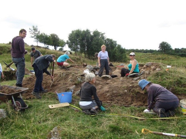
NOSAS members working at Mulchaich 16th August 2013

Over the years tradition has had it that there are the remains of a distillery dating back to the 18th Century at Mulchaich Farm, located in the district of Ferintosh on the Black Isle. The distillery site is about 200m NW of the farm and was previously unrecorded; it was in a sorry state being quite overgrown with whins and with the few open areas grossly trampled by cattle. In 2009 members of the North of Scotland Archaeological Society began a project which had as one of its aims the surveying and recording of the distillery site and that of the neighbouring chambered cairn (HER MHG 9083). The project also included a limited amount of historical documentary research following which a report was produced – see also Appendix II below for further details.

It was felt that together with the chambered cairn the distillery site would make an interesting and attractive place for people to visit. The landowners, the Dalgetty family, were happy to oblige with permission and for this we are very grateful. In addition the Adopt-a-Monument Scheme hosted by Archaeology Scotland were keen to help us with advice and limited funding, so in October 2012 NOSAS began a second phase of work at Mulchiach, preparing the site for public presentation. It is this later project that forms the chief focus of the following article.

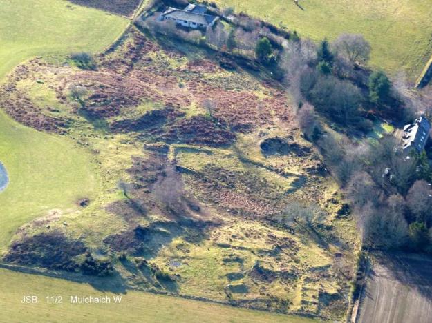
Mulchaich Farm, west settlement and chambered cairn – Aerial photo taken from the north

Mulchaich Farm, distillery site (west settlement) and chambered cairn – Aerial photo taken from the north

The Mulchaich Kiln

The main thrust of the work during the summer of 2013 was targeted at the kiln where the barley or bere, which had been allowed to germinate, would have been made into malt by gently heating it until it was dry . The kiln had all the characteristics of a corn drying kiln and the purpose of our exercise was to clear the rubbish that was inside it so that its features could be displayed and we could interpret them for visitors. The work was carried out as if it was an excavation; nothing structural was removed, everything was recorded as we went along, photographs were taken at all stages and a report was subsequently published.

The kiln bowl had been constructed on a small mound of glacial till which had been levelled off to form a platform. The platform was built up on the east side and reinforced with boulders and the kiln bowl itself was sunk into the natural morainic till by 200mm; likewise the flue and the area in front of the entrance which was sunk by 500mm.

Continue reading

Another Old Route through Ross-shire – Achanalt Station to Dalnachroich in Strathconon via Badinluchie

by Meryl Marshall (NOSAS)

What is believed to be an old droving route from Badinluchie, south of Loch Achanalt in Strath Bran, to Dalnachroich in Strathconon was followed by several NOSAS members on a sunny day in October.

Climbing up from Badinluchie

Climbing up from Badinluchie

The Roy map of c1750 has two roads from the east coast to the west through Ross-shire, one through Strathconon and one through Strath Bran. At this time they would hardly have been roads but more probably bridle ways easily traversed by ponies; a road from Contin to Poolewe through Strath Bran first appears in the records about the year 1760. From the late 1700s, and probably even earlier, communication with the Isle of Lewis passed through the tiny port of Poolewe, cattle were shipped from the Islands to join the droving routes which led eastwards to the tryst at Muir of Ord; John Knox was to report that he sailed from Stornoway to Poolewe in a small unworthy vessel used for the transport of cattle (Tour of the Highlands and Islands 1786).  Cattle export was to reach its height in the early 1800s during the Napoleonic Wars.

The main route by which the drovers headed east for Muir of Ord was via Loch Maree, Achnasheen and Strath Bran, although there were other routes to the north. Maps of the late 18th and early 19th century – John Ainslie 1789, Arrowsmith 1807 and John Thomson 1832, indicate a branch road heading south over the hills from Achanalt in Strath Bran to Strathconon via “Baud Leuchie”; this route would have made eminent sense for drovers wishing to avoid hazardous river crossings on their way to Muir of Ord.

Arrowsmith Map 1807 Part 1

Arrowsmith Map 1807 Part 1

Arrowsmith Map 1807 Part 2

Arrowsmith Map Detail 2


Continue reading

Old routes through Ross-shire: Luib, near Achnasheen, to Scardroy in Strathconon

by Meryl Marshall (NOSAS)

A six mile stretch of rough moorland, west of Achnasheen, is traversed by what was once a well made road generally 3 metres in width. Although it has fallen into disuse and is travelled only by the occasional walker, possibly doing a coast to coast trip, the road today is very distinct and forms a pleasant days’ ramble, especially when combined with an outward journey to Achnasheen on the Kyle of Lochalsh train (with homeward transport parked at Scardroy). But what are the origins of the road? and why did it fall out of use?

A route through Strathconon to Loch Carron had been in existence for centuries; it linked the east and west coast lands of the Clan Mackenzie. The Roy map of 1750 has the road passing NW from Scardroy to Luib on Loch Gowan, 3kms west of Achnasheen, and the first mention of an Inn at Luib, or Luibgargan as it is sometimes known, is on the Dorret map of 1750. A 1798 list of householders has John Macdonald, described as “vintner”, residing there and in 1814 Donald Sage passed this way: “Leaving Attadale in the morning I breakfasted at Luibgargan, proceeded on foot down Strathconan and rested during the night at Garve” (Memorabilia Domestica, Donald Sage, 1899 p191). Both the road and the Inn appear on other early maps too, the Ainslie map of 1789, Arrowsmith of 1807 and Thomson of 1830. It also appears on a Strathconon estate map of 1825 where it is annotated “the road from Loch Carron”. So quite clearly this was a route of some importance; how did it come to be abandoned?

Dorret Map

Dorret Map 1750 (detail; click on map for wider view)

Ainslie Map 1789

Ainslie Map 1789 (detail; click on map for wider view)

Continue reading