Category Archives: Loch Ness, Aird and Inverness

Inchberry Farm and Steading, near Beauly – A Relationship with Serendipity

by Roland Spencer-Jones

A new report entitled Inchberry – a settlement, a farm, a steading and a family has just been posted to the NOSAS website. It describes the history of a farm and steading at Inchberry, on the south side of the Beauly Firth. What was remarkable about the work that went into the report was that serendipity provided most of the information, rather than systematic archival research. That serendipity was in turn a product of relationships built up over many years. How often a chance encounter or a chance remark opens a door into new understanding or knowledge. Let’s see how it happened with Inchberry….

Serendipity One

The Lovat Estate Office in Beauly (c. NOSAS)

Out of the blue, on 8th March 2021 the Director of the Lovat Highlands Estate, Iain Shepherd, emailed me to say that there were some interesting graffiti on the walls of a steading at Inchberry and would I like to see them. I had got to know Iain well in 2018 when I was able to work on the Lovat map archive, at that time housed in the Estate Office in the middle of Beauly. The Estate then generously funded the digital scanning of all the maps in the archive, which were subsequently uploaded to the National Library of Scotland website. A relationship was born, which we had both appreciated since.

Graffiti of HMS Hood (c. Lovat Highland Estates)
Graffiti of a Spitfire (c. Lovat Highland Estates)
Continue reading

The Kebbuck Stone, Ardersier: A Lost Pictish Symbol Stone?

by Fiona Campbell-Howes

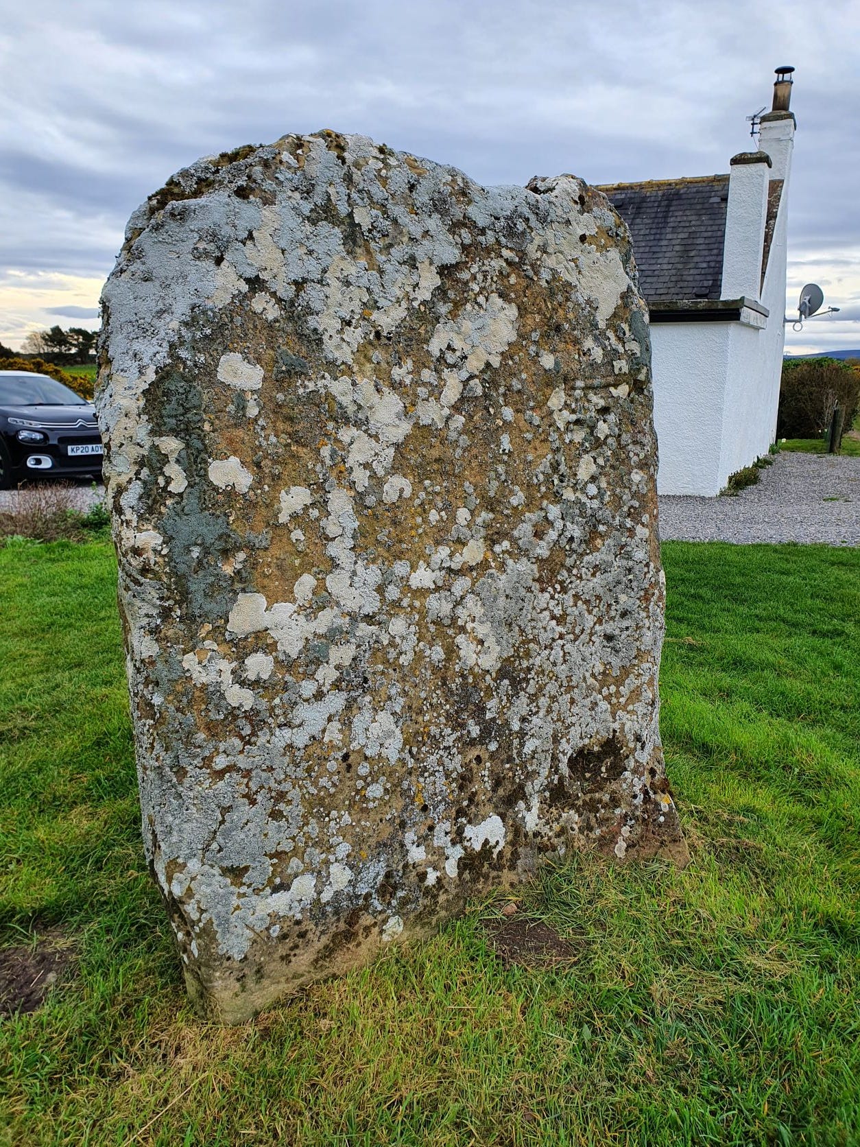
The cross-face of the Kebbuck Stone, eroded and overgrown with lichen

This is the Kebbuck Stone (see Canmore), a relief-carved cross slab dated to the 8th or 9th century, which today sits in the back garden of a cottage near Ardersier.

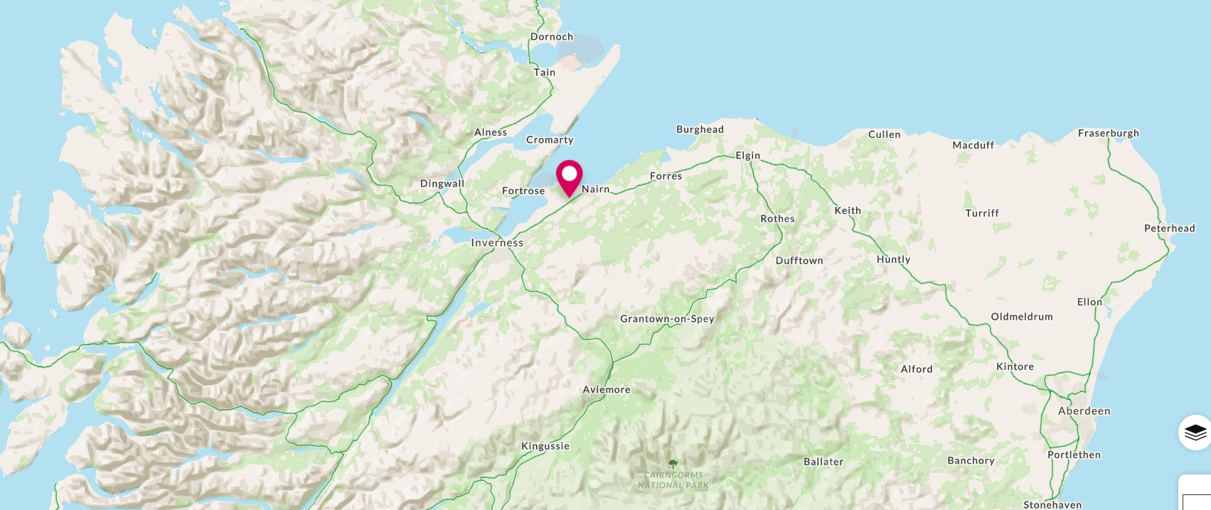
Map showing the location of the Kebbuck Stone in Nairnshire
Location of the Kebbuck Stone in Nairnshire


It’s usually overlooked in the corpus of early medieval (“Pictish”) stone sculpture because the carvings have almost completely worn away and the surface of the stone is overgrown with lichen.

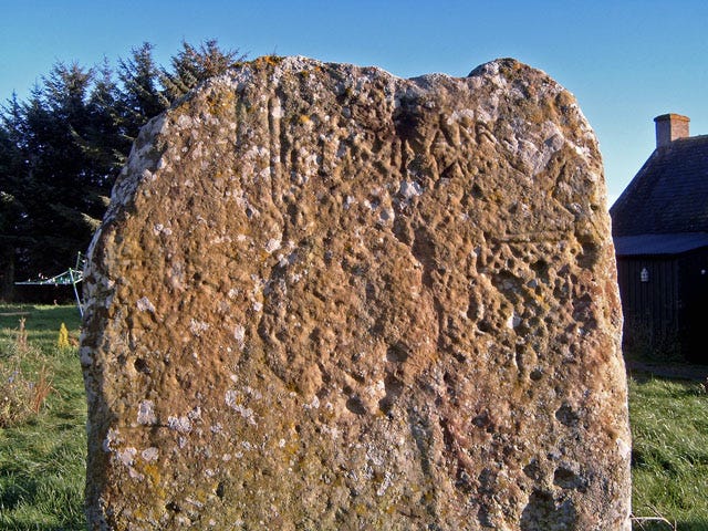
It was badly eroded even in 1893, when antiquarian George Bain wrote in his History of Nairnshire:

“The slab is very much wasted from the effects of weathering and ill-usage, but the faint outline of a Celtic cross can still be traced upon one side of it. It is a cross of the earliest form—incised and undecorated—and it would have made a most interesting memorial of early Christian times had it been better preserved.

Kebbuck Stone in evening sunlight, by Ian R. Maxwell (Geograph)
Continue reading

A Coastal Walk on the Moray Firth: Castle Stuart and Alturlie

by Anne Coombs

I don’t like the A96.  It’s a very busy road and the archaeology is not particularly exciting; crop marks and just the occasional cairn.  But here I was driving along from Inverness to Castle Stuart to meet the people from ScAPE, beginning their new recording project along the northeast coast.  The plan was to walk from Castle Stuart round towards Ardersier, with expectations of good company and a nice day out with a little bit of archaeology.

Aerial photo of the tide mill near Castle Stuart.

We walked past the old church and motte of Castle Stuart to the outfall of the Rough Burn where it flows into the Moray Firth.  It is a cliché to say it felt like we were stepping back in time, but looking out across to the Black Isle we could have been in a medieval landscape.  Salt marsh, an occasional seabird and nothing else.  Apart from, of course, a large bank across the edge of the salt marsh.  Not just any bank but one belonging to a tide mill (HER MHG36425).

So, let’s go back to the scene…… salt marshes, a substantial burn, an old church, motte and later castle.  Obviously, there must be a mill somewhere as part of this old settlement.  Tide mills don’t immediately come to mind in the Highlands, however if you have read Marion’s blog on Petty parish you would be expecting it.  They work on the same basic principle as any mill. A head of water drives a wheel, which turns the mill stones and grinds the corn.  A tide mill uses the sea water as its water source, as the tide comes in it fills the area behind the bank and once the tide turns, the water is kept behind the bank by the bank and a sluice gate until it is needed.  The site was duly recorded and on we went to a small wooden jetty, in disrepair but possibly not very old.  Next, we found a boat…..or rather the remains of a boat barely visible in the silt but definitely there.  Then out to the edge of the bay where the stones of a fish trap were being revealed by the outgoing tide. 

Fish Traps near Alturlie Point
Continue reading

The NOSAS Crannogs Project

by Richard Guest

I have long been fascinated by crannogs. These are articial island dwellings such as the one in Loch Achilty, pictured above (see Canmore).  I remember back in the 80’s tiptoeing across a partly submerged causeway to visit one in a Shetland lochan.  Then, later, visiting the reconstruction in Loch Tay and seeing a TV programme about it.  Later still, whilst on a Nautical Archaeology Society training course I met one of the divers who had been on the Loch Tay project and heard first hand what it was like to make such amazing discoveries.

About 10 years ago, my late wife Jonie and I decided to try and walk out to the Redcastle crannog in the Beauly Firth (see Canmore).  About twenty squelchy steps was enough to convince us that this was a BAD IDEA and we retreated to solid land.  And oh! The smell!  So the next expedition was by boat at high tide and we passed over Phopachy crannog (see Canmore), which we could see on the sounder but could make nothing out through the water.  Another trip at a lower state of tide, we could see the crannog but the water around it was too shallow to approach in the boat.  We didn’t try again.

What we did do was to dive around another crannog, the one in Loch Brora (see Canmore).  The water was so peaty we saw literally nothing.  We knew we had reached the bottom when we felt it beneath us.  I put my hand in front of my mask but couldn’t see it, even with a powerful torch.  I think I could feel some square timber but it might have been a modern fence post caught in weed.

More recently I became aware, through both diving and archaeology sources, of discoveries of Neolithic pottery found underwater around crannogs in the western isles (see Current Archaeology article).  This exploded the received wisdom that crannogs were of iron age to post medieval date.  Then in 2021 NOSAS were lucky enough to have a “Zoom” lecture about crannogs, by Michael Stratigos from the University of York, which is available on You Tube (below). This is when the idea for a NOSAS crannogs project was born.

Continue reading

The Demolition of a Cruck-Framed Building near Beauly

by Roland Spencer-Jones

Fig 1: Removing the corrugated iron reveals a modern timber roof and a cruck-frame

In early June 2020, I became aware that a neighbour on the braes below me was doing up an old cottage, with a 1970’s extension, that he had inherited from his father. He was one of four children brought up in the old cottage in the 1960’s. Once he had removed the corrugated iron roof from the cottage, a peat and heather roof was revealed. When that was removed a wooden cruck-frame appeared. I showed a photo (fig 1) to colleagues who immediately suggested that I should survey and record it. Cruck-framed buildings are not so common these days. There was additional interest in that the cruck-frame had been overlaid by a more modern roof and that the building is likely to be demolished.

Extract of 1:250000 OS map showing location of Ruisaurie crofting settlement. ©Ordnance Survey

How old is it? The online Lovat Estate maps show that the braes above, ie W of, Beauly were increasingly brought into crofting, gradually extending into moorland, between the mid-18th century and the early part of the 19th century. According to those maps, one of the crofts, Ruisaurie, had two croft numbers in 1757, eight numbers in 1798-1800, seventeen in 1823 and twenty-four in 1839. The crofts increased by both being sub-divided, and by new croft settlements being established on the higher ground. Confusingly, the numbering of the crofts changed over time, although by 1876 the croft numbering had become established to reflect the croft numbering now.

Fig 3: Extract of 1876 map showing extent of the Ruisaurie 11A croft © Lovat Highland Estates Ltd.

Continue reading

Raigmore Hospital, Inverness: From EMS to NHS

by Marion Ruscoe

Raigmore Hospital, 1948 © HES (Aerofilms Collection)

Raigmore Hospital was erected as part of the Emergency Medical Scheme (EMS) on part of  the Raigmore estate and opened in 1941.  The Emergency Medical Scheme was established to provide adequate medical facilities for expected wartime casualties and Raigmore was one of seven new hospitals built during the war.  They were all built to a standard design, but because of restrictions in the use of timber and steel, the buildings at Raigmore were brick, single storey and flat roofed.  An aerial photograph, taken in 1948, of the new hospital shows the layout to the south of Raigmore House on the east side of Inverness.   There were 16 individual wards and an isolation unit providing about 670 beds.  Staff accommodation was provided at the north-west corner of the site and a further collection of individual blocks between the staff accommodation and the wards housed administration, kitchens, dining rooms, laboratories and other services.

After the war, Raigmore continued to provide hospital services to Inverness and the surrounding area along with, principally, the R.N.I., Culduthel Hospital and Hilton Hospital but by the 1960s the facilities in Inverness were not meeting modern needs and in 1962 plans for a new general hospital to serve Inverness were put in place.   As an EMS hospital Raigmore was never designed to last for ever.  By 1966 work had begun on the new hospital for the Highlands and it was decided that it had to be at Raigmore, because that was where there was enough space to develop the facilities.  Phase 1 of the development was opened in 1970.  It incorporated the Outpatients Department, laboratories, pharmacy, physiotherapy and records.  Dr. James Bruce, who in 1947 was appointed consultant biochemist, finally got the new laboratory that he was promised at interview.

An aerial view of the hospital in 1972 shows Phase 1 at the bottom of the photo, but the original hospital buildings are still there and in use.  When comparing this view with the earlier view taken in 1948 the only other differences are that the walled garden has become part of the hospital car park, and the College of Nursing has been built to the right of the wards.

Continue reading

Peter May, the Commissioners, NOSAS and the National Library of Scotland – a story of discovery

by Roland Spencer-Jones (NOSAS)

“Coigach is a very large country”

In 1756 a young man was sent by his employers to Coigach, the rough open wild country west of Ullapool. His job was to measure and survey the land. But he wasn’t altogether happy in his task. He wrote to his employers on 21st July:

The estate of Coigach is a very large country, and the subject difficult and tedious to measure, being little else but high mountains with scattered woods, steep rocky places, and a number of lochs in the valleys, which with the great distance there is between houses makes me obliged to sleep in the open fields for several nights together, which is dangerous in a climate where so much rain falls. I wish (you) would condescend to allow me a tent or otherwise I’ll have great difficulty to go through. There is no such thing as sleeping in their houses in the summer time, they are so full of vermin. Everything is scarce and dear, my living costs me more here than it does in Aberdeen although I can scarcely get bear bannocks.

(Adams, 1979, pp10-11).

The man was Peter May, his employers were the Commissioners of the Board for the Forfeited Annexed Estates.

The battlefield of Culloden saw the demise of more than the men who fought there. The clan chiefs who “came out” had their land appropriated by the Crown. Much of it was then ravaged, particularly those estates nearest Culloden. The Lovat estate at that time centred on the seat of the Fraser clan, Castle Dounie, at the head of the Beauly Firth. Castle Dounie was burnt following the battle. The estate comprised the parishes of Kiltarlity, Kirkhill and Kilmorack, near Beauly, the lands of Stratherrick on the south side of Loch Ness and a small section of land on the north side of that Loch at Dalcattick and Portclair. The Mackenzie estate of Cromartie consisted of land around Cromarty on the Black Isle, New Tarbat on the north side of the Cromarty Firth, parcels of land on the Tarbat peninsula, Castle Leod (near Strathpeffer), and the lands of Coigach on the west coast. Castle Leod was the ancestral seat, New Tarbat became the seat in the late 17th century, and the lands of Coigach were obtained in the dowry of Margaret Macleod of Lewis in 1606 (Clough, 1990, p3).

New Tarbat House in the late 17th century ©Canmore

Continue reading

A Year of Highland Archaeology

by James McComas (NOSAS)

A Year of Highland Archaeology book cover, showing Tarradale Through Time excavation trench with the settings of a possible stone hut. The same trench yielded several rare antler tools.

NOSAS has just published A Year of Highland Archaeology: A Collection of the Projects and Activities of the North of Scotland Archaeological Society . This new book includes 10 articles which explore some of the diverse recent projects that we has been involved with. These range from large scale funded excavations through to group surveys and small scale research projects. They highlight Highland locations from the west to the east coast, from Speyside to Sutherland.

Projects featured include the lottery funded Tarradale Through Time Project, which in 2017 saw 6000 year old antler tools uncovered near Muir of Ord on the Black Isle.  These very rare finds included the remains of a harpoon point and two “T axes” left behind by hunter gatherers on the shores of the Beauly Firth. The T axes are two of only five examples so far known in the whole of Scotland. The trench where these were found also tantalisingly revealed the possible stone setting of a Mesolithic hut. Tarradale Through Time continues in Autumn 2019 with the excavation of potentially one of the largest barrow cemeteries in Scotland (further information at www.tarradalethroughtime.co.uk).

One of rare antler “T axes” found during Tarradale Through Time’s 2017 excavations.

Another chapter focuses on Torvean Hillfort, a neglected structure on the edge of Inverness. Torvean was perhaps constructed more than 2000 years ago, but it is today sadly under threat from persistent trail bike damage. A different chapter tells the much more positive story of how a collection of 400 historic maps relating to the Lovat Highland Estates, covering extensive areas west of Inverness, have now been scanned and made available online.

Map of Torvean Hillfort, Inverness showing destructive trail bike tracks

A different chapter still focuses on the NOSAS’s work with Scotland’s Rock Art Project. ScRAP aims to log as many as possible of the mysterious carved “cup marks” which appear on Scotland’s boulders and rock faces over a 5 year project. The precise date of these carvings, of which there are many good examples in the Highlands, is unknown but they are thought to have been mainly created in the Neolithic period around 6,000 to 4,000 years ago. Other archaeological locations explored in the book include Ormond Castle in Avoch, a prehistoric roundhouse landscape in Glen Urquhart, and Gruinard Island in Wester Ross.

3D Photogrammetry model of cup marked stone at Kinmylies, Inverness

Continue reading

Scotland’s Rock Art Project (ScRAP): An Update

by Alan Thompson (NOSAS)

Led by Dr Tertia Barnett, ScRAP is a five-year project which “aims to enhance understanding and knowledge of Scotland’s rock art through community co-production and research”.

NOSAS has been involved with the project since it began (see previous post), and members have tested and contributed to the design of the fieldwork during the pilot phase. For some time now we have been clear to make progress with the fieldwork, and as a result we are getting to know the prehistoric rock art in our area and beginning to appreciate its many different forms.

For our members, the attractions of rock art and of the ScRAP project are many, indoor and outdoor, group and individual. The challenge of making sense of the records in Canmore and the local HER; the challenge of finding the panels, known as well as new; fossicking (prospecting); cleaning and recording on site; examining the 3D models to confirm or amend our field observations; and getting a panel firmly and correctly on the record.

The process is now well established, and ScRAP has an excellent website at www.rockart.scot.

This blog post is an opportunity to present a few of the more interesting panels we have recorded to date, along with some personal observations.

Some Examples

When most people hear about ‘cup and ring boulders’ they think of the famous panels at Kilmartin – wide, flat outcrops of smooth rock onto which cups with multiple concentric rings have been carved. Few panels in our area are like this, but we will start first with one that is, at Easter Backlands of Roseisle.

Easter Backlands of Roseisle

This sandstone panel is both damaged and worn, but the rings around at least 9 and possibly 11 cups can be seen.  One cup has 3 concentric rings, and three others have two. Looking more closely the radial grooves which go out from some of the cups are also visible.

Easter Backlands of Roseisle

More typically in our area we find one or more simple cups generally on the highest point on rough (medium grained) schist boulders; for example Balnafoich 2.

Balnafoich 2

Balnafoich 2 is a large boulder of schist, 4.3 m by 3.0 m by 1.5 m high, with three well formed cups at its highest points. The panel is on an east facing slope, near to the confluence of the Rivers Nairn and Farnach (just visible in the background). It is one a group of four panels. A few meters away is Balnafoich 1 which is a flat slab of schist, flush with the ground. It boasts 25 cups and is quite different in character to its neighbour. Continue reading