Tag Archives: NOSAS report

Inchberry Farm and Steading, near Beauly – A Relationship with Serendipity

by Roland Spencer-Jones

A new report entitled Inchberry – a settlement, a farm, a steading and a family has just been posted to the NOSAS website. It describes the history of a farm and steading at Inchberry, on the south side of the Beauly Firth. What was remarkable about the work that went into the report was that serendipity provided most of the information, rather than systematic archival research. That serendipity was in turn a product of relationships built up over many years. How often a chance encounter or a chance remark opens a door into new understanding or knowledge. Let’s see how it happened with Inchberry….

Serendipity One

The Lovat Estate Office in Beauly (c. NOSAS)

Out of the blue, on 8th March 2021 the Director of the Lovat Highlands Estate, Iain Shepherd, emailed me to say that there were some interesting graffiti on the walls of a steading at Inchberry and would I like to see them. I had got to know Iain well in 2018 when I was able to work on the Lovat map archive, at that time housed in the Estate Office in the middle of Beauly. The Estate then generously funded the digital scanning of all the maps in the archive, which were subsequently uploaded to the National Library of Scotland website. A relationship was born, which we had both appreciated since.

Graffiti of HMS Hood (c. Lovat Highland Estates)
Graffiti of a Spitfire (c. Lovat Highland Estates)
Continue reading

David’s Fort Revisited – and a Strange Coincidence?

By Meryl Marshall

With movements restricted due to the coronavirus pandemic it was inevitable that I would find myself at David’s Fort, near Conan House, just 2kms from my home. This impressive earthwork, variously interpreted as a “motte”, a “moated homestead” (OS map) and a “moated site” has received lots of attention from NOSAS in the past, see Marion Ruscoe’s blog of 2016, but the site remains as mysterious as ever. I was pleased to see that the area is much more open than it used to be, but the surrounds are rapidly becoming overgrown with scrubby brambles, broom and whins. The visit set me thinking once again about the origins and history of the site, with more time at home I set about some online investigations.

David’s Fort (Canmore ID: 12866, Highland Council HER: MHG8986) is at NGR NH 5394 5328 and consists of an impressive wet ditch 4m deep enclosing a trapezoidal area measuring 25m from N to S and 26m to 32m transversely. The ditch is enclosed by an external bank standing up to 3m height but 1.5m externally. Internally the only feature visible is a circular depression 7m in diameter and 1m in depth in the western half; traces of what may have been a bridge spanning the ditch on the west side have also been reported (June 1979) The moat still contains water and was originally fed by a waterway running from an artificially constructed pond possibly of more recent origin 100.0m to the east, to a cut in the bank at the NE corner.

The site is located on the forested slope above the River Conon 1km to the east of Conan House. It is close to what, in the Medieval period, was a crossing of the River Conon. Here too was the old church of Logiebride (or Logie Wester), and the site of the Battle of Lagabraad in 1481. This area, at the “neck” of the Black Isle, will almost certainly have been a meeting point of routeways for centuries, if not millennia.

David’s Fort looking SW

A processed image of Davids Fort from a lidar survey (contains public sector information licensed under the Open Government Licence v3.0) © A Thompson. This model has also been uploaded to Sketchfab and can be seen in 3D at https://sketchfab.com/3d-models/davids-fort-d26cbff5d5184af18d157f7b6be94dad

Continue reading

David’s Fort: a Medieval Motte?

by Marion Ruscoe (NOSAS)

In around 2000 Janet Hooper, Allan MacKenzie and I undertook a survey of David’s Fort, a rather enigmatic site in Balavil Wood, near Conon Bridge.  Our intention was to survey the site, clarify its purpose and investigate the related documentary and contextual information.  We did arrange a geophysical survey which was cancelled due to Foot and Mouth, and that was replaced with a later walkover of Balavil Wood.  David’s Fort itself is scheduled, but there are other features in the immediate area which may be related and which are worthy of notice.

David's Fort aerial photograph by Jim Bone

David’s Fort aerial photograph by Jim Bone

David’s Fort (NH5394 5328; HER MHG8986) is essentially a large earth mound surrounded by a ditch, surrounded by an embankment.  The mound and embankment were created by digging out the ditch.  It’s trapezoidal in shape, and the top of the mound measures approximately 80 x 85 feet.  The moat is around 15 feet deep and is partially filled with water.  There’s no sign of any structures on the top of the mound, but these would probably have been wooden and evidence would not have survived the trees and bracken which have invaded the site.

There is a dip on the west end and a corresponding dip in the embankment with a track running down to the mediaeval road which runs from Tarradale on the Beauly Firth to the ford over the River Conon.  It’s been assumed that this is where the entrance was, though, since the embankment is considerably lower than the top of the mound, any bridge would either be very sloped, or mounted on a framework which raises the question “why the dip in the embankment and the very obvious path leading from that dip?”  The embankment surrounding the mound has been extended for a short distance at three of the corners.  The purpose of this is not clear.  Water was fed into the moat via a channel leading from a lochan to the east of the site and controlled by a sluice but this channel has been damaged by the embankment which carries the power lines.

Dip in embankment, indicating possible original entry. 1998

Dip in embankment, indicating possible original entry. 1998

Continue reading

Carn Glas – A Life in Seven Acts

by Roland Spencer-Jones (NOSAS)

DSC_0008 The Opening of the Cairn 12.10.15

The Opening of the Cairn 12.10.15

Carn Glas is one of a cluster of six Neolithic cairns at the base of the Black Isle in Ross-shire. A trio of local archaeology groups have collaborated with the Adopt-a-Monument team of Archaeology Scotland in its restoration. The opening party for the “new” cairn happened during Highland’s Archaeology Fortnight, on October 12th. Why did it need restoring? Well, it’s a story in Seven acts:

Act One started with the construction of a Cromarty-Orkney-type chambered cairn approximately 3600 BC, as the Neolithic farming package developed in the area. The passages of the chamber at the heart of the huge cairn were aligned north-west to south-east. They consisted of an entrance passage to the south-east, leading to a middle chamber, leading to an inner chamber. An excavation over two seasons by Tony Woodham in 1955-6 produced a series of artefacts dating to this period – a leaf-shaped Neolithic arrowhead, other flints, and numerous pottery shards.

Neolithic Arrowhead from 1956 excavation

Neolithic Arrowhead from 1956 excavation    (c) National Museums of Scotland

Continue reading

Mulchaich 18th Century Distillery, Ross-shire: a NOSAS Project

by Meryl Marshall (NOSAS)

Mulchaich Kiln excav 16th Aug13 008

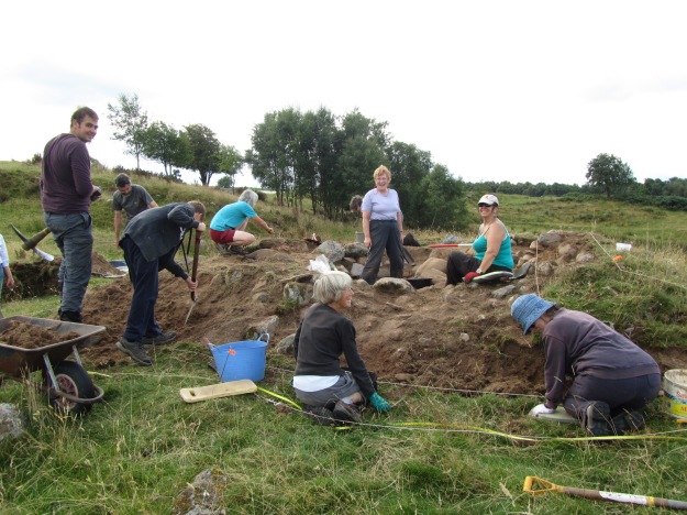
NOSAS members working at Mulchaich 16th August 2013

Over the years tradition has had it that there are the remains of a distillery dating back to the 18th Century at Mulchaich Farm, located in the district of Ferintosh on the Black Isle. The distillery site is about 200m NW of the farm and was previously unrecorded; it was in a sorry state being quite overgrown with whins and with the few open areas grossly trampled by cattle. In 2009 members of the North of Scotland Archaeological Society began a project which had as one of its aims the surveying and recording of the distillery site and that of the neighbouring chambered cairn (HER MHG 9083). The project also included a limited amount of historical documentary research following which a report was produced – see also Appendix II below for further details.

It was felt that together with the chambered cairn the distillery site would make an interesting and attractive place for people to visit. The landowners, the Dalgetty family, were happy to oblige with permission and for this we are very grateful. In addition the Adopt-a-Monument Scheme hosted by Archaeology Scotland were keen to help us with advice and limited funding, so in October 2012 NOSAS began a second phase of work at Mulchiach, preparing the site for public presentation. It is this later project that forms the chief focus of the following article.

Mulchaich Farm, west settlement and chambered cairn – Aerial photo taken from the north

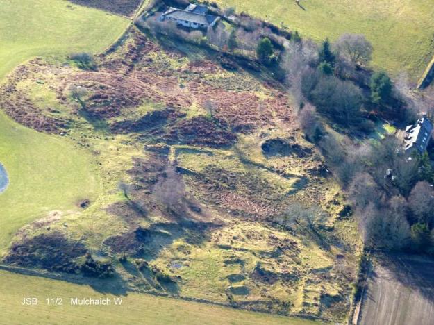
Mulchaich Farm, distillery site (west settlement) and chambered cairn – Aerial photo taken from the north

The Mulchaich Kiln

The main thrust of the work during the summer of 2013 was targeted at the kiln where the barley or bere, which had been allowed to germinate, would have been made into malt by gently heating it until it was dry . The kiln had all the characteristics of a corn drying kiln and the purpose of our exercise was to clear the rubbish that was inside it so that its features could be displayed and we could interpret them for visitors. The work was carried out as if it was an excavation; nothing structural was removed, everything was recorded as we went along, photographs were taken at all stages and a report was subsequently published.

The kiln bowl had been constructed on a small mound of glacial till which had been levelled off to form a platform. The platform was built up on the east side and reinforced with boulders and the kiln bowl itself was sunk into the natural morainic till by 200mm; likewise the flue and the area in front of the entrance which was sunk by 500mm.

Continue reading