Category Archives: Black Isle

Mesolithic Encounters: Tarradale Shell Midden Excavation, Autumn 2023

by Eric Grant

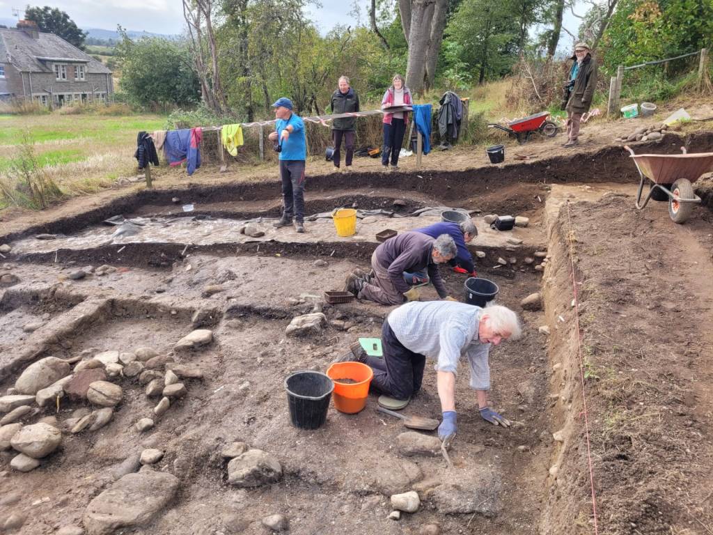
2023 excavations in Trench 2B

In 2017 the Tarradale Through Time project excavated a shell midden (known as site 2B) located on a raised beach terrace at the foot of a palaeo-cliff about 150 m south-east of Tarradale House, see previous blog post.  In September to October 2023 the site was revisited by the Tarradale Archaeological Team in order to continue the earlier investigation. The original 2017 excavation trench was approximately 8 m x 6 m and revealed a complex sequence of marine shell midden deposits comprising mussel, cockle, periwinkle, oyster, whelk along with animal and fish bones. A number of possible struck quartz flakes and worked flint was also found within the midden but compared with shell midden excavations in other parts of Scotland, site 2B was lithic poor. Several significant worked bone and antler artefacts were recovered from the shell midden including the remains of two antler T-axes and a fragment of a biserial antler harpoon.

2023 excavations in Trench 2B

A series of radiocarbon dates from the 2017 excavations gave results between 4832 and 3643 cal BC. This range of more than 1000 years suggests that the site had been occupied, if not continuously, at least regularly, from the Mesolithic into the early Neolithic period. A number of stone settings was found within the excavated area and on the east side of the trench an underllying spread of cobbles and sandy gravel was interpreted as the original raised beach surface. Owing to lack of time in 2017, the western side of the trench was not excavated to the same depth, so the excavations in 2023 had the primary objective of removing the remaining shell midden deposits and evaluating the underlying deposits and any potential structures. It is apparent that the shell midden site had been disturbed through the ages by agricultural activity forming rig and furrow and the only reason that site has survived to the present is that it is bounded on one side by a fence and on the north by the palaeo-cliff, making it impossible for larger agricultural machines to plough the area. If this had not been the case the site would have been totally destroyed. Indeed, a considerable area to the south of the surviving site has been severely truncated by ploughing.
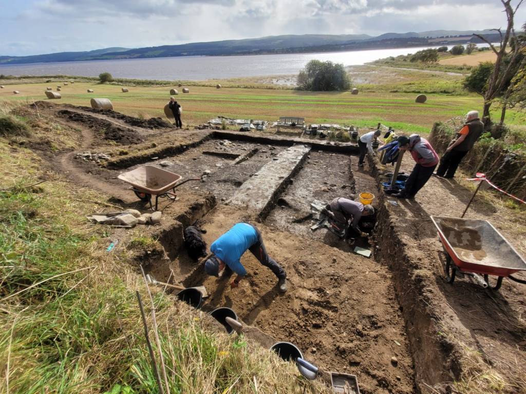
Trench extension to the NW shown in the foreground
Continue reading

My Highland Adventure: Diving Loch Achilty Crannog and HMS Natal

by Duncan Ross

During lockdown, apart from eating too many pancakes, NASAC (Nautical Archaeology Society affiliated diving club) member Duncan Ross set himself a grand future task of visiting different kinds of underwater archaeological sites around Britain. This summer he managed to add a couple of unique Scottish sites to his gradually-expanding list.

After around two years of communication, in August 2022 I was invited to help out on a crannog investigation in the fairly anonymous Loch Achilty, just a little north of Inverness city. Assisting North of Scotland Archaeology Society (NOSAS) member Richard Guest and his intrepid team, I spent two days at a most-tranquil setting scuba diving, investigating, recording and taking photos and film of a site that could be anything from a couple of hundred years to a couple of thousand years old. 

Richard Guest explores mysterious timber and rocks around the Loch Achilty crannog: Image: Duncan Ross

Crannogs are a fairly unchartered area in the field of archaeology, and most questions about their creation and the purpose of their locations within lochs remain unanswered and open to speculation. All that usually remains is an artificial island of stones piled on top of one another – artefacts and human traces are frustratingly rare, as are diagnostic patterns that could lead to a method of classification. The crannog centre at Loch Tay focuses on the iron age roundhouse model that was discovered there, but little proof exists that others were constructed and utilised in the same way. The depth of the Loch Achilty crannog, previously unrecorded, is an ultra-accessible 2.5 metres. Needless to say, dive times were extremely long for Richard and myself.

Richard Guest and Duncan Ross prepare to place garden canes around the crannog to aid with measurements. Image: Elizabeth Blackburn
Continue reading

Castle Hill “Henge” at Muir of Ord – A Controversial Structure

by Roland Spencer-Jones

Muir of Ord Golf Club may be unique in having a green on top of a scheduled ancient monument. Castle Hill, the 13th green, is an artificially modified mound, standing at the north end of a ridge, proud of the surrounding flat ground. Its perimeter is delimited by a raised bank inside of which is a circular ditch, with two gaps at NW and SE. This bank and ditch enclose an oval flat area approximately 28 m by 21 m. The ridge probably represents an alluvial glacial moraine before the end of it was subsequently modified.

There has been considerable discussion and debate in the archaeological literature over the last 350 years as to the nature of this feature, when it was created, and for what purpose. However, whatever its nature, it is special, recognised as such by being included in the list of ancient monuments in Section 12 of the Ancient Monuments Consolidation and Amendments Act 1913. This important act of scheduling was reported to the Right Honourable Lord Lovat in a registered letter dated 11th April 1957. In the scheduling documentation[1] it was called Castle Hill Fort or Henge. Scheduling is the process that “identifies, designates and provides statutory protection for monuments and archaeological sites of national importance”, with damage to a scheduled site potentially incurring criminal charges. This became relevant in the early 1980’s, see later.

Castle Hill in 1972 © Historic Environment Scotland: John Dewar Collection

Early Descriptions of Castle Hill

The first historical mention of this prominent feature was towards the end of the 17th century in a massive volume of archaeological recording, the Monumenta Britannica, written by probably Britain’s first archaeologist, John Aubrey (Aubrey, 1665-93). In it, Aubrey records part of a letter he received in 1692 from a Dr James Garden, Professor of Theology in the King’s College at Aberdeen. Aubrey had written to many local dignitaries and antiquarians throughout Northern Britain asking for information about stone monuments. He was delighted to receive this full response from Dr Garden in which the latter refers to a sacred grove thus: “I … have gotten information of two groves yet standing which are reputed sacred. One of them (which stands near to a place called Taradale in the parish of Killernen and shire of Nairn) is enclosed with a trench or dry ditch having two entries to it where the ditch is filled up or rather the ground has never been broken: all that live near it hold it as sacred, and will not cut so much as a rod out of it: my informer adds that, hard by, there is a cornfield where he conjectures there has been one of the Monuments, because in it there are several big stones such as those Monu­ments use to consist of, fallen down and out of order.” Taradale, now Tarradale, is the name given to the settlement that later came to be called Muir of Ord once the railway arrived in 1862. Garden’s description of the “sacred grove” fits nicely with the structure now called Castle Hill. Also note the description of standing stones in the vicinity, which we will come on to later.

Continue reading

Barrow-Loads of Barrows: Excavating a Monumental Pictish Cemetery at Tarradale on the Black Isle

by Eric Grant

Drone aerial photo showing barrows of different sizes and shapes (Drone photo: Andy Hickie)

In the first three weeks of September 2019 volunteers from the North of Scotland Archaeological Society supported by members of the local community excavated a suspected Pictish cemetery in a field near Tarradale House. Aerial photographs had previously shown the possible existence of a number of barrow graves in the area but there was little to see on the surface as the mounds had been almost totally ploughed away but their surrounding ditches appeared as ghostly outlines on the aerial photographs. A small, but growing, number of barrow cemeteries has been identified in Scotland but only a few excavated. Aerial photographs show the remains of at least 28 square and round barrows at Tarradale making it currently the second largest burial ground of this type in Scotland. The site could originally have been more extensive as parts of it have either been ploughed out or are too deeply buried to show in aerial photographs. Recent high-resolution photographs taken by drone have suggested the existence of more barrows towards the perimeter of the field and possibly into an adjacent field. Our excavations showed that Tarradale was a barrow cemetery of monumental proportions and potentially one of the most important in Scotland.

Although we are still waiting for radiocarbon dates from the Tarradale excavation, the presence of round and square barrows and their spacing and distribution leaves little doubt that we are dealing with a Pictish cemetery potentially from the 5th or 6th century AD, an important period in the formation of early kingdoms in northern Britain. Tarradale lies in the eastern side of Ross-shire on the Beauly Firth and only six miles from Craig Phadrig, an important stronghold and regional capital in the Kingdom of Fortriu. Part of this centralisation of power was reflected in the creation of monumental cemeteries and Tarradale may have been the burial place of the local elite. No Pictish symbol stones have been found at Tarradale, although symbol stones, including cross slabs with symbols on them have been found in adjacent parishes, the nearest being the recently discovered Conan stone three miles from Tarradale. However, in the same field as the barrow cemetery, a fortified settlement was excavated in the 1990’s; no primary dating evidence for the Picts was obtained but on stylistic grounds pottery from the fortified site has been dated to between AD 300-800 so this may well be the settlement focus of some of the people buried nearby.

Plan of barrow cemetery trenches (plan by Steve Birch)

Continue reading

Droning on about Tarradale

by Andy Hickie

Drone image of Tarradale Through Time barrow cemetery dig, as featured in “Current Archaeology” November 2019.

Back in 2017, I caved in to the demands of consumerism, and purchased a new quadcopter, a Phantom 3 Advanced, which is equipped with a camera and GPS unit. I flew multiple flights around Avoch but, after a while, the novelty of seeing one’s house from the air at different angles and altitudes begins to wear thin, and I began to wonder what I could actually do with a drone. Having always had an interest in archaeology and, spurred on by seeing some of the images Alan Thompson of NOSAS had created, I decided to carry out a few experiments of my own.

My first flights took in locations such as the distillery and settlement at Mulchaich, and the features of Kinbeachie castle – sites which had already been mapped by Alan by drone, the results of which I could use as a ‘benchmark’ against which I could compare those of my own.

At the same time, I began experimenting with various flight planning apps which allow for off-line autonomous flight planning, as well as online platforms for image processing. I found that “DroneDeploy” and “Mapsmadeasy” combined provided a fairly user-friendly pipeline, whereby image capture and photogrammetry can produce georeferenced photomosaics and digital surface models (DSMs). These can then be imported into software such as QGIS for further processing.

Having found the software which satisfied my needs, I then turned my attention to potential sites which I could map – and decided on the cropmarks of the Barrow Cemetery at Tarradale. At this point, my intent was purely to satisfy my own curiosity – just to see what I could see, and how it would compare with the archaeology found at the forthcoming 2019 dig.

And so, on 10 June 2018, accompanied by my daughter Emma to act as co-pilot and “spotter”, I visisted Tarradale to map the area with the drone. I can still recall the excitement I felt as the images began to appear on the monitor of the remote controller, which showed the cropmarks were developing. However, my satisfaction was tempered somewhat when I got home and began to process the photographs. Although the cropmarks were indeed evolving, the crop was insufficiently ripe, and many of the details remained hidden (see image below).

Continue reading

A Year of Highland Archaeology

by James McComas (NOSAS)

A Year of Highland Archaeology book cover, showing Tarradale Through Time excavation trench with the settings of a possible stone hut. The same trench yielded several rare antler tools.

NOSAS has just published A Year of Highland Archaeology: A Collection of the Projects and Activities of the North of Scotland Archaeological Society . This new book includes 10 articles which explore some of the diverse recent projects that we has been involved with. These range from large scale funded excavations through to group surveys and small scale research projects. They highlight Highland locations from the west to the east coast, from Speyside to Sutherland.

Projects featured include the lottery funded Tarradale Through Time Project, which in 2017 saw 6000 year old antler tools uncovered near Muir of Ord on the Black Isle.  These very rare finds included the remains of a harpoon point and two “T axes” left behind by hunter gatherers on the shores of the Beauly Firth. The T axes are two of only five examples so far known in the whole of Scotland. The trench where these were found also tantalisingly revealed the possible stone setting of a Mesolithic hut. Tarradale Through Time continues in Autumn 2019 with the excavation of potentially one of the largest barrow cemeteries in Scotland (further information at www.tarradalethroughtime.co.uk).

One of rare antler “T axes” found during Tarradale Through Time’s 2017 excavations.

Another chapter focuses on Torvean Hillfort, a neglected structure on the edge of Inverness. Torvean was perhaps constructed more than 2000 years ago, but it is today sadly under threat from persistent trail bike damage. A different chapter tells the much more positive story of how a collection of 400 historic maps relating to the Lovat Highland Estates, covering extensive areas west of Inverness, have now been scanned and made available online.

Map of Torvean Hillfort, Inverness showing destructive trail bike tracks

A different chapter still focuses on the NOSAS’s work with Scotland’s Rock Art Project. ScRAP aims to log as many as possible of the mysterious carved “cup marks” which appear on Scotland’s boulders and rock faces over a 5 year project. The precise date of these carvings, of which there are many good examples in the Highlands, is unknown but they are thought to have been mainly created in the Neolithic period around 6,000 to 4,000 years ago. Other archaeological locations explored in the book include Ormond Castle in Avoch, a prehistoric roundhouse landscape in Glen Urquhart, and Gruinard Island in Wester Ross.

3D Photogrammetry model of cup marked stone at Kinmylies, Inverness

Continue reading

Tarradale Through Time: 2018 Excavations

by Eric Grant

In September 2018 two sites were investigated by TARRADALE THROUGH TIME near Muir of Ord. These were a fortified enclosure just west of Gilchrist church and a rather enigmatic and possibly ritual site south of Gilchrist church, but located on Balvattie Farm.

Gilchrist Promontory Fort

The Gilchrist fort is a rather unusual monument  and walking past it gives no clue to its existence, size or age. Canmore describes it as a promontory fort based on their interpretation of crop marks as the arcs of three concentric ditches “Apparently designed to cut off approach to a tongue of low-lying and comparatively level ground running NW into marshland, they are in effect part of the defensive system of a promontory fort measuring about 85 m by 30 m”.

In addition to the black-and-white photographs on the Canmore database, the late Jim bone, who was an enthusiastic archaeologist and also a pilot, took some good colour photographs of the site. Jim’s aerial photograph shows three dark green curved features representing the fort’s ditches on the east side of the promontory. The ditches are now under cultivation and have been filled in and ploughed flat so there is nothing to see above ground; it is only the aerial photographs that have encouraged archaeologists to see this as a fortified promontory. It is unusual to find a promontory fort inland unless it is in a situation like this where it is surrounded by water or marshland. Most hill and promontory forts in Scotland appear to have been constructed during the late Bronze Age and Iron Age and the latest ones were built or reoccupied in Pictish times.

Aerial photograph of Gilchrist showing ditches as dark green curves (JS Bone Collection)

Our research agenda sought to identify and characterise the ditches, and to ascertain when the fort was constructed, how long it was occupied and what activities may have taken place there. Three large trenches were initially opened, one running at right angles across the defensive ditches, a second running from the long side of the fort down into the bog and a third on the highest part of the interior of the fort. We were very quickly able to establish that the three ditches seen on aerial photographs did exist, with a hint of a fourth ditch closer into the fort. The outermost ditch was reasonably shallow but the second ditch was a massive construction 5-6 m wide at the top and sloping steeply to about 1.5 m below the plough soil though we consider that the upper part of the ditches have been lost due to ploughing and the intervening banks of excavated material flattened. The third innermost ditch was not quite so deep, but right on the edge of the actual fort area we found what may be an inner ditch that might have continued round the fort perimeter as a wall and perhaps with a timber fence palisade on top or just in front.

Plan of Gilchrist excavations showing crop marks and trenches (HAS)

Continue reading

Scotland’s Rock Art Project (ScRAP): An Update

by Alan Thompson (NOSAS)

Led by Dr Tertia Barnett, ScRAP is a five-year project which “aims to enhance understanding and knowledge of Scotland’s rock art through community co-production and research”.

NOSAS has been involved with the project since it began (see previous post), and members have tested and contributed to the design of the fieldwork during the pilot phase. For some time now we have been clear to make progress with the fieldwork, and as a result we are getting to know the prehistoric rock art in our area and beginning to appreciate its many different forms.

For our members, the attractions of rock art and of the ScRAP project are many, indoor and outdoor, group and individual. The challenge of making sense of the records in Canmore and the local HER; the challenge of finding the panels, known as well as new; fossicking (prospecting); cleaning and recording on site; examining the 3D models to confirm or amend our field observations; and getting a panel firmly and correctly on the record.

The process is now well established, and ScRAP has an excellent website at www.rockart.scot.

This blog post is an opportunity to present a few of the more interesting panels we have recorded to date, along with some personal observations.

Some Examples

When most people hear about ‘cup and ring boulders’ they think of the famous panels at Kilmartin – wide, flat outcrops of smooth rock onto which cups with multiple concentric rings have been carved. Few panels in our area are like this, but we will start first with one that is, at Easter Backlands of Roseisle.

Easter Backlands of Roseisle

This sandstone panel is both damaged and worn, but the rings around at least 9 and possibly 11 cups can be seen.  One cup has 3 concentric rings, and three others have two. Looking more closely the radial grooves which go out from some of the cups are also visible.

Easter Backlands of Roseisle

More typically in our area we find one or more simple cups generally on the highest point on rough (medium grained) schist boulders; for example Balnafoich 2.

Balnafoich 2

Balnafoich 2 is a large boulder of schist, 4.3 m by 3.0 m by 1.5 m high, with three well formed cups at its highest points. The panel is on an east facing slope, near to the confluence of the Rivers Nairn and Farnach (just visible in the background). It is one a group of four panels. A few meters away is Balnafoich 1 which is a flat slab of schist, flush with the ground. It boasts 25 cups and is quite different in character to its neighbour. Continue reading

A Little Piece of Coppice at Coulmore, Formerly on the Redcastle Estate

By Jonathan Wordsworth

Cycling regularly along the north shore of the Beauly Firth from North Kessock to Tarradale, I have noted just past Coulmore Point a small patch of woodland with a collection of twisted multi-stemmed trees.  Consisting predominantly of oak but with a mixture of species including ash and beech, the trees are widely spaced and used as shelter by stock grazing the field above.  As a result the wood has an open and sparse aspect.

The curving and multiple stems of the trees in the woodland show that this is a rare survival for this area of a former coppiced woodland, where the stems were cut down to  supply timber on a regular cycle of  15-20 years.

Coulmore and the woodland copse shown on current Bing aerial photography.  Note the caravan park at bottom right of photograph to help locate the woodland site.

Earlier maps show it was one of two similar sized copses set beside the road and on the edge of the raised beach.  They are both shown as wooded on the land utilisation survey of the 1930s shown below, though the western copse has now disappeared.

Reproduced with the permission of the National Library of Scotland https://maps.nls.uk/index.html

Continue reading