Tag Archives: Tarradale

Mesolithic Encounters: Tarradale Shell Midden Excavation, Autumn 2023

by Eric Grant

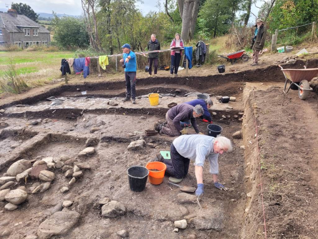
2023 excavations in Trench 2B

In 2017 the Tarradale Through Time project excavated a shell midden (known as site 2B) located on a raised beach terrace at the foot of a palaeo-cliff  about 150 m south-east of Tarradale House, see previous blog post.  In September to October 2023 the site was revisited by the Tarradale Archaeological Team in order to continue the earlier investigation The original 2017 excavation trench was approximately 8 m x 6 m and revealed a complex sequence of marine shell midden deposits comprising mussel, cockle, periwinkle, oyster, whelk along with animal and fish bones. A number of possible struck quartz flakes and worked flint was also found within the midden but compared with shell midden excavations in other parts of Scotland, site 2B was lithic poor. Several significant worked bone and antler artefacts were recovered from the shell midden including the remains of two antler T-axes and a fragment of a biserial antler harpoon.

2023 excavations in Trench 2B

A series of radiocarbon dates from the 2017 excavations gave results between 4832 and 3643 cal BC. This range of more than 1000 years suggests that the site had been occupied, if not continuously, at least regularly, from the Mesolithic into the early Neolithic period. A number of stone settings was found within the excavated area and on the east side of the trench an underllying spread of cobbles and sandy gravel was interpreted as the original raised beach surface. Owing to lack of time in 2017, the western side of the trench was not excavated to the same depth, so the excavations in 2023 had the primary objective of removing the remaining shell midden deposits and evaluating the underlying deposits and any potential structures. It is apparent that the shell midden site had been disturbed through the ages by agricultural activity forming rig and furrow and the only reason that site has survived to the present is that it is bounded on one side by a fence and on the north by the palaeo-cliff, making it impossible for larger agricultural machines to plough the area. If this had not been the case the site would have been totally destroyed. Indeed, a considerable area to the south of the surviving site has been severely truncated by ploughing.
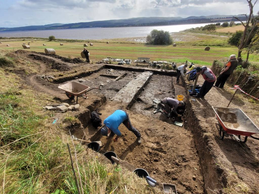
Trench extension to the NW shown in the foreground
Continue reading

Castle Hill “Henge” at Muir of Ord – A Controversial Structure

by Roland Spencer-Jones

Muir of Ord Golf Club may be unique in having a green on top of a scheduled ancient monument. Castle Hill, the 13th green, is an artificially modified mound, standing at the north end of a ridge, proud of the surrounding flat ground. Its perimeter is delimited by a raised bank inside of which is a circular ditch, with two gaps at NW and SE. This bank and ditch enclose an oval flat area approximately 28 m by 21 m. The ridge probably represents an alluvial glacial moraine before the end of it was subsequently modified.

There has been considerable discussion and debate in the archaeological literature over the last 350 years as to the nature of this feature, when it was created, and for what purpose. However, whatever its nature, it is special, recognised as such by being included in the list of ancient monuments in Section 12 of the Ancient Monuments Consolidation and Amendments Act 1913. This important act of scheduling was reported to the Right Honourable Lord Lovat in a registered letter dated 11th April 1957. In the scheduling documentation[1] it was called Castle Hill Fort or Henge. Scheduling is the process that “identifies, designates and provides statutory protection for monuments and archaeological sites of national importance”, with damage to a scheduled site potentially incurring criminal charges. This became relevant in the early 1980’s, see later.

Castle Hill in 1972 © Historic Environment Scotland: John Dewar Collection

Early Descriptions of Castle Hill

The first historical mention of this prominent feature was towards the end of the 17th century in a massive volume of archaeological recording, the Monumenta Britannica, written by probably Britain’s first archaeologist, John Aubrey (Aubrey, 1665-93). In it, Aubrey records part of a letter he received in 1692 from a Dr James Garden, Professor of Theology in the King’s College at Aberdeen. Aubrey had written to many local dignitaries and antiquarians throughout Northern Britain asking for information about stone monuments. He was delighted to receive this full response from Dr Garden in which the latter refers to a sacred grove thus: “I … have gotten information of two groves yet standing which are reputed sacred. One of them (which stands near to a place called Taradale in the parish of Killernen and shire of Nairn) is enclosed with a trench or dry ditch having two entries to it where the ditch is filled up or rather the ground has never been broken: all that live near it hold it as sacred, and will not cut so much as a rod out of it: my informer adds that, hard by, there is a cornfield where he conjectures there has been one of the Monuments, because in it there are several big stones such as those Monu­ments use to consist of, fallen down and out of order.” Taradale, now Tarradale, is the name given to the settlement that later came to be called Muir of Ord once the railway arrived in 1862. Garden’s description of the “sacred grove” fits nicely with the structure now called Castle Hill. Also note the description of standing stones in the vicinity, which we will come on to later.

Continue reading

Jim Bone: Aerial Photography of Archaeological Sites

Jim was a founder member of NOSAS, which celebrated its 20th anniversary in 2018. He was known in the Highlands for providing important aerial photos of numerous archaeological sites over many years. Sadly, Jim died on June 16th, after a long and wearisome illness. His extensive collection of aerial photographs has been gifted to NOSAS and will form the JS Bone Collection, in his memory. This is the story he wrote of himself, in the months before he died. (Introduction revised Sep 2018).

Aerial photograph of Mulchaich, Ross-shire. The settlement , distillery and chambered cairn at Mulchaich were the subject of NOSAS projects between 2009 and 2013. See the blog post.

It appears to me that people can be divided into two categories – those who love flying, and those who do not.  Brought up in close proximity to Prestwick Airport, I recall watching aircraft there, and determined that I would one day find out more about aviation.  Inspired by a selection of Biggles books, I joined the local ATC (Air Training Corps) squadron, enabling me to sample flight for the first time in 1950 in an elderly Anson.  Military aircraft have a distinctive odour of aluminium and oil, complemented in this case by an off-putting whiff of vomit, but I enjoyed this first ‘air experience’ flight along the Ayrshire coast.  For the next flight, I borrowed a folding camera, and tried a few shots through the rather scratched Perspex window.  Surprisingly, the results came out quite clearly, and another interest was born.

Going to University in Glasgow, I lost no time in finding the HQ of the University Air Squadron (GUAS), and was fortunate enough to be accepted as a Cadet Pilot in the RAFVR.  This offered a high standard of flying training, during 1953-7, provided by experienced RAF instructors at Scone Airfield outside Perth.  Our Chipmunk aircraft was state of the art at that time, but cameras were not encouraged on training sorties.  At the end of my four years, I asked if I could take a camera with me on a dual flight with my instructor, having noticed some archaeological sites which I wanted to photograph.  By opening the hood, I was able to take quite a good shot of a hill fort to the south of Perth, which presaged further attempts in later years.  The Squadron experience qualified me for a Preliminary Flying Badge – a sort of junior wings – and allowed me to apply for a Private Pilot’s Licence, costing a very reasonable ten shillings, when I left the unit. Continue reading

Tarradale Archaeological Project – Findings to Date

by Dr. Eric Grant (NOSAS)

Background to the project. The Tarradale Archaeological Project started as a private initiative around 2008 and was incorporated as an approved NOSAS research project in 2011. The Tarradale archaeological project aims to investigate and record the surviving archaeological evidence of the multi-period archaeological landscape of the Tarradale area and to interpret the chronological development of settlement and resource utilisation in the study area. The main activity of the project so far has been field walking which has been very successful and as data has been collected and analysed the parameters of the project have moved and the aims extended.

Aerial photo of Tarradale area with Tarradale house in the foreground. Tarradale Castle (destroyed 1308) was probably located above and below the steep bank in the field immediately below Tarradale House. ). (Picture by courtesy of Jim bone).

Aerial photo of Tarradale area with Tarradale house in the foreground. Tarradale Castle (destroyed 1308) was probably located above and below the steep bank in the field immediately below Tarradale House. (Picture by courtesy of Jim Bone).

1. Location and extent of the Tarradale study area. The study area comprises about 750 hectares of mainly agricultural land at the eastern end of the parish of Urray on the northern side of the inner Beauly Firth in Ross-shire. Historically the area was co-terminous with the old landholding unit of Tarradale  estate and the ecclesiastical parish of Gilchrist or Tarradale, which was a separate parish until becoming amalgamated with the parish of Urray in the late 16th The historical centre of Tarradale was the old parish church, now surviving only as a mausoleum at Gilchrist. Following the building (or rebuilding) of Tarradale House in the 17th century, Tarradale House became the administrative centre (caput) of the estate.

A large part of the area is raised estuarine beaches and that area today is flat or gently undulating high-quality agricultural land that is regularly ploughed. To the north of the former raised beaches the land rises towards the Mulbuie Ridge as undulating hillside mainly covered with boulder clay. Apart from Gilchrist Chapel and some standing stones probably erected in the Bronze Age, there are few visible archaeological monuments in the area that is intensively ploughed, although aerial photographs show cropmarks that can be interpreted as ring ditches, pits and enclosures. This contrasts with the more upland and less intensively cultivated area where there are standing monuments including Tarradale chambered cairn and an indeterminate feature which has been called a henge but is better referred to with the more general term of earthwork.

Tarradale chambered cairn

Tarradale chambered cairn

Continue reading