Tag Archives: Archaeological dig

Mesolithic Encounters: Tarradale Shell Midden Excavation, Autumn 2023

by Eric Grant

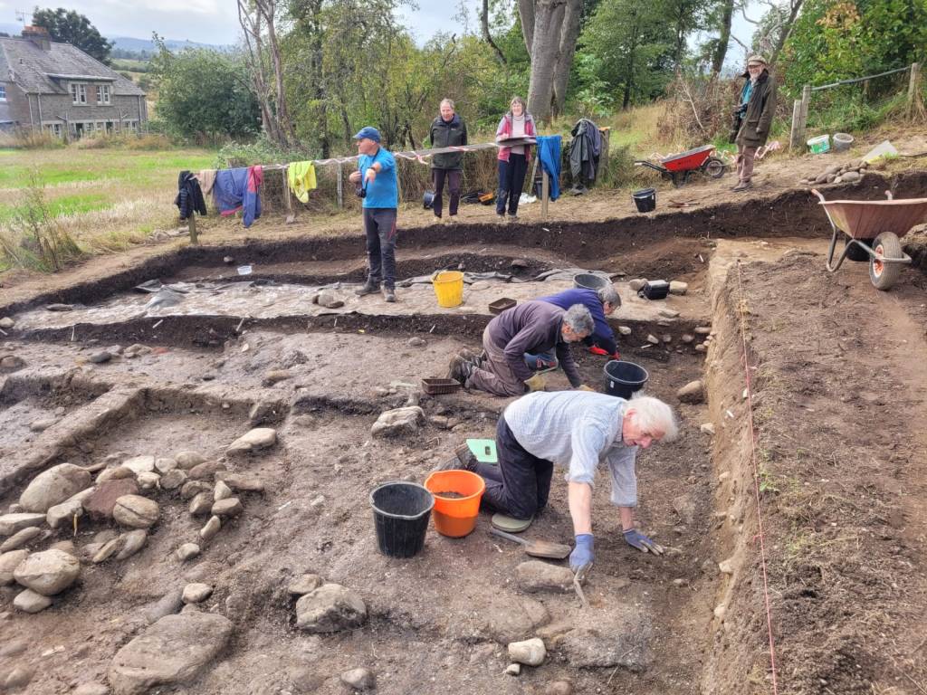
2023 excavations in Trench 2B

In 2017 the Tarradale Through Time project excavated a shell midden (known as site 2B) located on a raised beach terrace at the foot of a palaeo-cliff about 150 m south-east of Tarradale House, see previous blog post.  In September to October 2023 the site was revisited by the Tarradale Archaeological Team in order to continue the earlier investigation. The original 2017 excavation trench was approximately 8 m x 6 m and revealed a complex sequence of marine shell midden deposits comprising mussel, cockle, periwinkle, oyster, whelk along with animal and fish bones. A number of possible struck quartz flakes and worked flint was also found within the midden but compared with shell midden excavations in other parts of Scotland, site 2B was lithic poor. Several significant worked bone and antler artefacts were recovered from the shell midden including the remains of two antler T-axes and a fragment of a biserial antler harpoon.

2023 excavations in Trench 2B

A series of radiocarbon dates from the 2017 excavations gave results between 4832 and 3643 cal BC. This range of more than 1000 years suggests that the site had been occupied, if not continuously, at least regularly, from the Mesolithic into the early Neolithic period. A number of stone settings was found within the excavated area and on the east side of the trench an underllying spread of cobbles and sandy gravel was interpreted as the original raised beach surface. Owing to lack of time in 2017, the western side of the trench was not excavated to the same depth, so the excavations in 2023 had the primary objective of removing the remaining shell midden deposits and evaluating the underlying deposits and any potential structures. It is apparent that the shell midden site had been disturbed through the ages by agricultural activity forming rig and furrow and the only reason that site has survived to the present is that it is bounded on one side by a fence and on the north by the palaeo-cliff, making it impossible for larger agricultural machines to plough the area. If this had not been the case the site would have been totally destroyed. Indeed, a considerable area to the south of the surviving site has been severely truncated by ploughing.
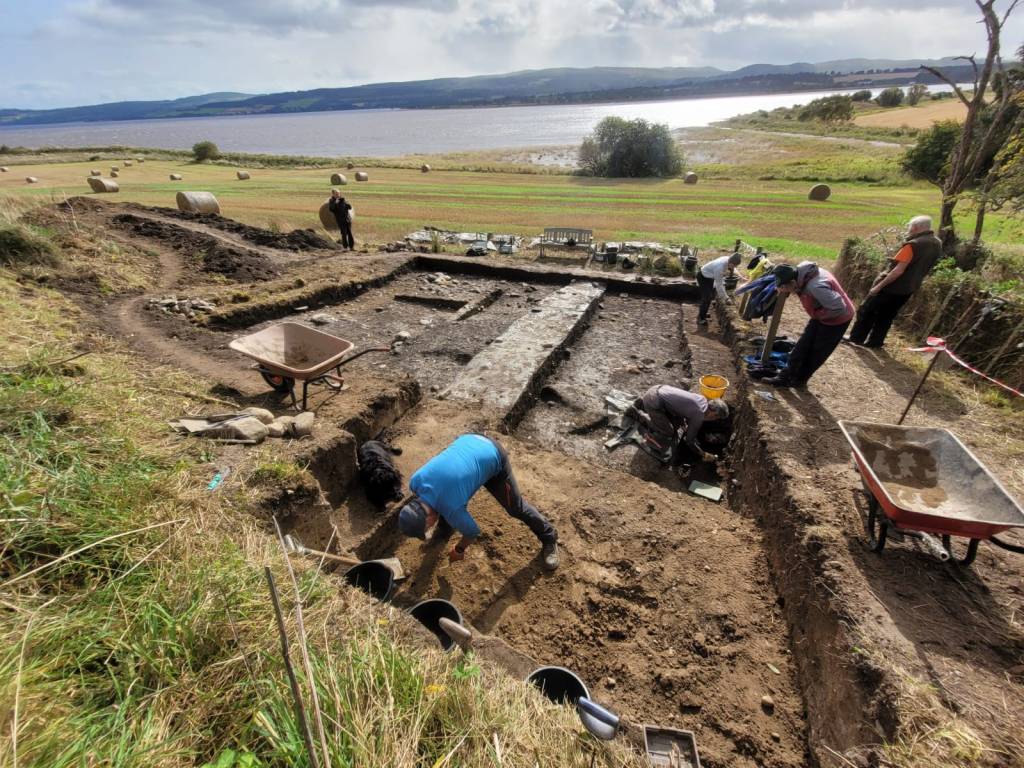
Trench extension to the NW shown in the foreground
Continue reading

Rosemarkie Caves Excavations: Interpreting the results of three years of excavations – 2016 to 2018

by Steven Birch

This article is a repost from the Rosemarkie Caves Website – see original here.

June 2018 saw a strong team from the Rosemarkie Caves Project carry out a third consecutive season of excavation in a group of coastal caves between Rosemarkie and Eathie. The fieldwork took place in two of the Learnie Caves, continuing the excavations to investigate cave function in Learnie 1A and Learnie 1B (Dead Horse Cave). The caves are located in the same headland below Learnie Farm, which also houses Smelter’s Cave (Learnie 2B), where the Rosemarkie Man discovery was made in 2016 (see previous blog posts here and here), along with substantial evidence for early medieval metalworking.

As in previous excavations, some of the best evidence for the use and function of the caves to emerge this year related to the 19th to early 20th century, including the usual leather shoe soles and leather off-cuts, snips of metal, sherds of window glass and worked bone/horn. The excellent preservation found in many of these caves also produced other organic remains including worked wood in Dead Horse Cave. Some of the more recognisable wood elements comprised fragments of roundwood around 6-8mm in diameter, some of which had trimmed ends. Further analysis of these finds is required, but it is possible that some of this material derives from the manufacture of baskets or fish traps. Other artefacts associated with this period of use included ceramics, bottle glass, a metal spoon, knife blades and handles, the remains of a small penknife including a part of the finely decorated bone handle, iron fittings, bone and mother of pearl buttons, several potential stone tools, and the ubiquitous clay pipe fragments. Several objects manufactured from copper alloy were also recovered including studs, pins, three low-denomination coins and fragments from an oil or paraffin lamp. In the upper levels of Learnie 1A, we recovered a large number of old shotgun cartridges, which may have been used to shoot rabbits and birds (the recent analysis of the animal bones from previous year’s excavations by Karen Kennedy has indicated high numbers of rabbit bones in the faunal assemblage from this period).

Composite pipe fragment from Learnie 1B.

Continue reading

Rosemarkie Caves Excavations 2017

by Steve Birch

2017 saw a second consecutive season of excavation by the Rosemarkie Caves Project in the series of coastal caves between Rosemarkie and Eathie. Four caves were chosen for targeted excavation by the team. This included further work in Smelter’s Cave (2B) where the Rosemarkie Man discovery was made last year (see blog post), along with substantial evidence for early medieval metal working .

Some of the best evidence for the use and function of the caves to emerge this year related to the 19th century, including the usual leather shoe soles and leather off-cuts, snips of metal, and working in bone/horn. We also recovered good economic evidence for the use of the caves during this period, which once analysed, will provide some detail with regards to how the people lived and what they ate!

Above: A child’s leather boot in situ. Below: A 3 holed bone button. Probable 19th C. artefacts from Cave 1B.

Unfortunately, the hard work to uncover further evidence of the metalworking activity outside 2B failed to materialise…..here, we found evidence for the deposition from material generated within the caves through time such as fire-cracked stones, charcoal and ash, shellfish, animal bone (cattle, sheep and pig) and some large fish (including cod and ling). This area, below the drip-line of the cave, was also probably quite a dangerous place to carry out any activities. A number of large rocks were uncovered here that had fallen from the cliff above. We did recover some metalworking residues including a hearth base, three pieces of iron slag, and one fragment of vitrified furnace wall.

The trench outside Cave 2B, aka Smelter’s Cave

Continue reading

Rhynie Excavations Season 4 (2016)

By Cathy MacIver (on behalf of the REAP Project Team)

A fourth season of excavation took place at the Craw Stane, Rhynie over August – September 2016. The project was led by REAP Project Directors Dr Gordon Noble, University of Aberdeen and Dr Meggen Gondek, University of Chester.

Aerial photographs and geophysical surveys had identified curvilinear enclosures around the Craw Stane, one of the few symbol stones remaining in situ in Scotland (Plate 1).

image001

Plate 1: Craw Stane with Tap O ‘Noth hillfort (©Cathy MacIver)

Previous seasons of work at the Craw Stane (one of seven Class I Pictish symbol stones from the area) in 2011, 2012 and 2015 had demonstrated that these enclosures took the form of an inner and outer ditch and a later palisade structure with associated postholes.

Excavations in past seasons had revealed a number of high status objects including fragments of Late Roman Amphora, glass beads, metal pins, glass vessel fragments and evidence of metal working in the form of metal working tongs, slag (metal working waste) and clay moulds for metal objects. The features date the site to the early medieval period and radiocarbon dates from the ditches and other internal features confirmed a relatively short 5th-6th C construction, occupation and abandonment of the site.

image003

Plate 2: Rough draft of the excavations from 2011, 2012 and 2015. A work in progress!

The 2016 excavations aimed to investigate areas of the site that hadn’t been looked at before, continuing to use the successful strip and map approach employed in previous years. This involved 4 large areas or trenches (Plate 3) where the topsoil was removed by machine and watched by archaeologists. The areas were then cleaned by hand by a team of archaeologists, students and volunteers, using hoes, krafses and eventually trowels. This made archaeological features more visible and easier to record. Plans of the site were created using DGPS (accurate to the nearest cm) and aerial photography using a drone. Areas with more complexity were drawn by hand.

image005

Plate 3: Aerial view of the 2016 trenches

Continue reading

Cromarty Medieval Burgh Excavations 2013-2016: An Overview

by Mary Peteranna and Steve Birch.

DCIM100MEDIADJI_0010.JPG

Aerial view of Reeds Park during excavation 2015, looking towards the modern town and the Cromarty Firth (Garry MacKay).

The Cromarty Medieval Burgh Community Archaeology Project, which has been investigating the lost remnants of Cromarty’s historic medieval centre, has uncovered evidence of a catastrophic burning event along with a wealth of information about the development of a small Scottish burgh. The archaeological site in Reeds Park, Cromarty had been buried below a farmer’s field for over 120 years, before began investigations in 2013 after coastal erosion revealed hints of settlement. The project, which has attracted over 700 volunteers and thousands of visitors, has been dubbed by medieval specialists ‘one of the most important medieval excavations happening in Scotland.’

Although the core of the medieval burgh of Cromarty was thought to have been located at the base of the castle brae, to the southeast of the present town, the presence of any surviving remains of the settlement were completely unknown before digging began. Now, working with a range of specialists, including historians and artefact experts the archaeologists are piecing together the exciting archaeological results spanning periods of settlement between the 13th to 19th centuries. In 2015-2016, after several seasons of digging, the excavation has come down to the earliest layers and provided a detailed look at the layout of the medieval town

cromartylayersl1-16-july-2015-1

Two corrected aerial photographs of the Cromarty excavation site by Alan Thompson. Above is the view towards the end of excavations in 2015.

cromarty2016flight1v1x2-ortho-rev

…and this image shows the substantial progress made by the end of the 2016 season.

The burgh of Cromarty was set in a strategically important location, controlling the entrance to the Cromarty Firth and the ferry crossing on the coastal route north of Inverness via Nigg, the most direct route to the medieval shrine of St Duthac’s in Tain. Cromarty was a natural location for a medieval power centre, with good coastal access and rich agricultural hinterland, strategically located on a key frontier zone in Northern Scotland. Unlike other areas of the north and Highland regions that were under clan control, Cromarty fell under the feudal authority of the Scottish crown. Although there is little documentary evidence for the town’s medieval history, it has been suggested that it was the logical location for a thanage in the 11th/12th centuries. A castle situated at Cromarty would have been a sensible location to establish royal authority on this borderland. While it was documented that the town’s sheriffdom had been established by 1266, little was known about the early history and layout of medieval Cromarty.

The archaeologists’ work from 2013-2016 has provided a detailed picture of the transitioning burgh, showing the buildings, property boundaries and zones of activity within an area focused on a former road alignment, referred to mysteriously as Thief’s Row in the 18th century. The latest buildings recorded on the site, dating to the 19th century  were located on the north side of the road; rectangular stone-built structures running parallel to Thief’s Row and set within plots of land demarcated by single coursed stone boundaries. The foundations of earlier buildings, most likely constructed during the closing stages of the 17th century mirrored the footprints of those latest buildings, displaying multiple phases of restructuring within these centuries. Artefacts associated from this period consist of low status ceramics and glass, and personal objects representing general subsistence living. Continue reading

Craig Phadrig Vitrified Hillfort, Inverness

The following is based on a transcript of notes by Mary Peteranna (AOC) for her presentation at the Highland Archaeology Festival Conference 2015. It describes fieldwork at Craig Phadrig hillfort carried out by AOC Archaeology in early 2015 on behalf of Forestry Commission Scotland, see Data Structure Report.

Craig Phadrig (Canmore ID 13486, HER MHG 3809) is located on the west side of lnverness, a prominent position overlooking River Ness and entrance to the Beauly/Moray Firth. The Beauly Firth marked a southern boundary of an area defined in the north by the Dornoch Firth landscape, supposedly held by the Decantae tribe in the lron Age as shown in Ptolemy’s map. Knock Farrell and Ord Hill hillforts are in line of sight, and a third possible fort is at Torvean In Inverness (Canmore ID 13549, HER MHG 3749).

2892 Craig Phadrig AP 3 (low res)

Aerial view of Craig Phadrig, Inverness, the Kessock Bridge and Ord Hill (Forestry Commission Scotland).

Craig Phadrig LANDSCAPE (low res)

A visualisation of the same scene as it might have appeared in prehistory (Forestry Commission Scotland).

Craig Phadrig is a prominent landscape feature, referred to at the time of James Vl in 1592. It is an oblong fort, a type which clusters around the Moray Firth region. Similar forts in East Scotland such as Finavon, Dunnideer and Tap o’ Noth also feature lack of entrance and massive walls suggesting an exclusive use. Many show evidence for lron Age construction, abandonment and secondary re-use.

Previous survey and excavation. Numerous previous surveys have been conducted on Craig Phadrig, probably sparked by Penant’s 1769 Tour of Scotland where he mentions vitrified stone. Plan shows the 2013 RCAHMS survey with the estimated area of these excavations.

canmore_image_SC01386712

Craig Phadrig. Plan of fort incorporating results of RCAHMS survey (Sept 2013) and earlier surveys (Canmore).

Finally, in 1971/72 Alan Small and Barry Cottam dug for two seasons, from which only an interim report after the first season was produced. lmage of the inner rampart from 1971; Small found that the inner rampart had been built sometime in the 4th Century BC and that the wall core was significantly vitrified. He also noted significant disturbance by other earlier excavations.

Continue reading

The Achavanich Beaker Burial Project: New Research on the Bronze Age of Northern Scotland

by Maya Hoole

In 2014, whilst working with the Highland Council Historic Environment Team, I came across the record of a Bronze Age beaker burial from Caithness in the Highland HER records (MHG13613). Although the site was discovered and subject to a rescue excavation in 1987, and some preliminary post-excavation had been undertaken, it had never been fully researched or published. The burial was positioned in a rare rock-cut pit with a stone lined cist, complete with cap stone. Inside were the remains of a young female (fondly known as Ava, her name an abbreviation of the place of discovery), aged 18-22 years old, accompanied by: a highly decorated beaker, three pieces of flint and the scapula of an ox or cow. Within seconds of opening the file and starting to read I was completely captivated. At that moment, I had no idea of the impact of my curiosity. I was totally clueless as to what was in store and completely oblivious to the fact that two years down the line my passion for the site would not only have increased but it would have extended far beyond myself.

The Beaker from the Achavanich cist burial (Maya Hoole©)

The Beaker from the Achavanich cist burial (Maya Hoole©)

The project began with my own research: I sorted the paper archives, located the artefacts at the Caithness Horizons museum, and subsequently photographed, measured, recorded and illustrated them. I went on to: re-discover the exact location of the site, re-create site plans, analyse the decoration on the beaker, make comparisons on a national scale and build a database and complete record of the artefacts. I bashfully presented my findings at a couple of conferences and… then things started to get interesting. At the very heart of the project was research. The initial goal was always to find out more about the individual buried at this site and to increase our knowledge of Bronze Age society in Northern Scotland. With the help of many different organisations and individuals, I applied for funding and soon found myself talking to experts (and to BBC news reporters, twice!) who were interested in developing our understanding of the site.

Dr Tom Booth of Natural History Museum examining the cranium from the Achavanich cist burial (Maya Hoole©)

Dr Tom Booth of Natural History Museum examining the cranium from the Achavanich cist burial (Maya Hoole©)

Continue reading

The Picts at Garbeg and Whitebridge

by James McComas (NOSAS)

The Pictish people of the mid to late first millenium AD once inhabited what is now northern and eastern Scotland. They left very little written record and the evidence of buildings so far identified are sparse. Perhaps their most obvious remains in the landscape are the enigmatic symbol stones and the imprints of their burial sites.

Although modern Angus and Perthshire have traditionally been seen as the Pictish heartland, in recent years new research is reveavaluating the importance of the northern picts, north of the Mounth. Two highland burial sites which feature impressive upstanding remains are to be found on opposite sides of Loch Ness; at Garbeg near Drumnadrochit, and at Whitebridge in Stratherrick. Pictish funerary practices appear to have been diverse (see our earlier blog post), however barrow* cemeteries have been identified as one recognisable form. Round and square type ditched barrows appear alongside each other at both Garbeg and Whitebridge – a feature thought to be unique to the Pictish cemetery.

Side by side comparison of a plan of part of the Garbeg cemetery and a quadcopter aerial photo by Alan Thompson. (The brown patches on the photo are the result of recent gorse clearance, and dark green areas are piles of cut vegetation.) The barrows excavated by Wedderburn and Grime on this plan are nos 1,2,3 and 8.

Side by side comparison of a plan of part of the Garbeg cemetery and a quadcopter aerial photo by Alan Thompson. (The brown patches on the photo are the result of recent gorse clearance, and dark green areas are piles of cut vegetation.) The barrows excavated by Wedderburn and Grime on this plan are nos 1,2,3 and 8.

Garbeg and Whitebridge were visited by NOSAS field trips in 2014/ 2015 and Garbeg has also been the subject of gorse clearance, quadcopter photography (blog post section 4) and QGIS survey by the group. Subsequently in 2015 many NOSAS members were involved with survey and excavation by the University of Aberdeen’s Northern Picts Project on possibly contemporaneous building remains at Garbeg.

The cemetery at Garbeg (Canmore ID 12281, HER MHG3361) consists of 23 square and round barrows with surrounding ditches. The barrows are thought to cover single long cist burials. They are situated on a natural plateau at an altitude of some 300m on open moorland used for rough grazing.  The immediately surrounding landscape is one rich in archaeological remains, including prehistoric field systems, groups of hut circles and a series of burnt mounds which are largely thought to predate the Pictish period.

Members of NOSAS at a field visit to Garbeg, November 2014

Members of NOSAS at a field visit to Garbeg, November 2014

Continue reading

Tarradale Archaeological Project – Findings to Date

by Dr. Eric Grant (NOSAS)

Background to the project. The Tarradale Archaeological Project started as a private initiative around 2008 and was incorporated as an approved NOSAS research project in 2011. The Tarradale archaeological project aims to investigate and record the surviving archaeological evidence of the multi-period archaeological landscape of the Tarradale area and to interpret the chronological development of settlement and resource utilisation in the study area. The main activity of the project so far has been field walking which has been very successful and as data has been collected and analysed the parameters of the project have moved and the aims extended.

Aerial photo of Tarradale area with Tarradale house in the foreground. Tarradale Castle (destroyed 1308) was probably located above and below the steep bank in the field immediately below Tarradale House. ). (Picture by courtesy of Jim bone).

Aerial photo of Tarradale area with Tarradale house in the foreground. Tarradale Castle (destroyed 1308) was probably located above and below the steep bank in the field immediately below Tarradale House. (Picture by courtesy of Jim Bone).

1. Location and extent of the Tarradale study area. The study area comprises about 750 hectares of mainly agricultural land at the eastern end of the parish of Urray on the northern side of the inner Beauly Firth in Ross-shire. Historically the area was co-terminous with the old landholding unit of Tarradale  estate and the ecclesiastical parish of Gilchrist or Tarradale, which was a separate parish until becoming amalgamated with the parish of Urray in the late 16th The historical centre of Tarradale was the old parish church, now surviving only as a mausoleum at Gilchrist. Following the building (or rebuilding) of Tarradale House in the 17th century, Tarradale House became the administrative centre (caput) of the estate.

A large part of the area is raised estuarine beaches and that area today is flat or gently undulating high-quality agricultural land that is regularly ploughed. To the north of the former raised beaches the land rises towards the Mulbuie Ridge as undulating hillside mainly covered with boulder clay. Apart from Gilchrist Chapel and some standing stones probably erected in the Bronze Age, there are few visible archaeological monuments in the area that is intensively ploughed, although aerial photographs show cropmarks that can be interpreted as ring ditches, pits and enclosures. This contrasts with the more upland and less intensively cultivated area where there are standing monuments including Tarradale chambered cairn and an indeterminate feature which has been called a henge but is better referred to with the more general term of earthwork.

Tarradale chambered cairn

Tarradale chambered cairn

Continue reading

Carn Glas – A Life in Seven Acts

by Roland Spencer-Jones (NOSAS)

DSC_0008 The Opening of the Cairn 12.10.15

The Opening of the Cairn 12.10.15

Carn Glas is one of a cluster of six Neolithic cairns at the base of the Black Isle in Ross-shire. A trio of local archaeology groups have collaborated with the Adopt-a-Monument team of Archaeology Scotland in its restoration. The opening party for the “new” cairn happened during Highland’s Archaeology Fortnight, on October 12th. Why did it need restoring? Well, it’s a story in Seven acts:

Act One started with the construction of a Cromarty-Orkney-type chambered cairn approximately 3600 BC, as the Neolithic farming package developed in the area. The passages of the chamber at the heart of the huge cairn were aligned north-west to south-east. They consisted of an entrance passage to the south-east, leading to a middle chamber, leading to an inner chamber. An excavation over two seasons by Tony Woodham in 1955-6 produced a series of artefacts dating to this period – a leaf-shaped Neolithic arrowhead, other flints, and numerous pottery shards.

Neolithic Arrowhead from 1956 excavation

Neolithic Arrowhead from 1956 excavation    (c) National Museums of Scotland

Continue reading